Alcácer do Sal geodata
Alcácer do Sal (District of Setúbal) is a seat of a second-order administrative division; located in Portugal in Europe/Lisbon (GMT+1) time zone. With population of 9,198 people, there are 239 cities with bigger population in this country. Compared to other cities in Portugal, 81.9% of cities are located further ↑North; 53.8% of cities are located further ←West and 70.5% of cities have higher elevation than Alcácer do Sal. Note1
Administrative division(s):
- Level 1: District of Setúbal
- Level 2: Alcácer do Sal
- Level 3: Alcácer do Sal (Santa Maria do Castelo)


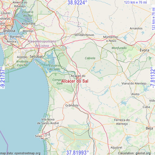
Alcácer do Sal GPS coordinates[2]
38° 22' 23.736" North, 8° 30' 51.984" West
| Map corner | latitude | longitude |
|---|---|---|
| Upper-left | 38.9224°, | -9.21757° |
| Center: | 38.37326°, | -8.51444° |
| Lower-right: | 37.81993°, | -7.81132° |
| Map W x H: | 122.6×122.6 km | = 76.2×76.2mi |
| max Lat: | 42.11337° ⇑81.9% North |
| Alcácer do Sal: | 38.37326° |
| min Lat: | ⇓18.1% South 32.6448° |
| min Long | Alcácer do Sal | max Long |
| -31.17847° | -8.51444° | -6.27308° |
| W 53.8%⇐ | ⇒46.2% E |
Elevation
Elevation of Alcácer do Sal is 49 m = 161 ft, and this is 128 m = 420 ft below average elevation for this country.
| Max E: |
1008 m = 3307 ft | 70.5% |
| Avg. | 177 m = 581 ft | |
| Alcácer do Sal | 49 m = 161 ft | |
Min E: |
-128 m = -420 ft | 29.5% |
See also: Portugal elevation on elevation.city.
Geographical zone
Alcácer do Sal is located in North temperate zone (between Tropic of Cancer and the Arctic Circle). Distance of this Northern Tropic circle is 1660.8 km =1032 mi to South.| Distance of | km | miles | from Alcácer do Sal |
|---|---|---|---|
| North Pole | 5740.4 | 3566.9 | to North |
| Arctic Circle | 3134.5 | 1947.7 | to North |
| Tropic Cancer | 1660.8 | 1032 | to South |
| Equator | 4266.7 | 2651.2 | to South |


Nearby cities:
15 places around Alcácer do Sal: (largest is in red/bold)
• Alvito
47.4 km =29.5 mi,  105°
105°
• Azeitão
46.4 km =28.8 mi,  290°
290°
• Comporta
23.7 km =14.7 mi,  271°
271°
• Grândola
22.3 km =13.9 mi,  191°
191°
• Moita
51.6 km =32.1 mi,  306°
306°
• Montemor-o-Novo
40.2 km =25 mi,  40°
40°
• Palmela
40.1 km =24.9 mi,  302°
302°
• Pinhal Novo
45 km =28 mi, 309°
• Quinta Do Conde
50.7 km =31.5 mi, 294°
• Quinta do Anjo
43.1 km =26.8 mi, 300°
• Santiago do Cacém
42.6 km =26.5 mi,  201°
201°
• Santo André
41.9 km =26 mi,  213°
213°
• Setúbal
36.6 km =22.7 mi, 297°
• Vendas Novas
34.1 km =21.2 mi,  8°
8°
• Viana do Alentejo
44.7 km =27.8 mi,  95°
95°
Sources, notices
• [Note1] Compared only with cities in Portugal existing in our database
• [Src1] Map data: © OpenStreetMap contributors (CC-BY-SA)
• [Src2] Other city data from geonames.org with taken over terms of usage.
• [Src3] Geographical zone / Annual Mean Temperature by Robert A. Rohde @ Wikipedia
