Venda do Pinheiro geodata
Venda do Pinheiro (Lisbon) is a populated place; located in Portugal in Europe/Lisbon (GMT+1) time zone. With population of 4,950 people, there are 427 cities with bigger population in this country. Compared to other cities in Portugal, 66.2% of cities are located further ↑North; 83.8% of cities are located further →East and 78.3% of cities have lower elevation than Venda do Pinheiro. Note1


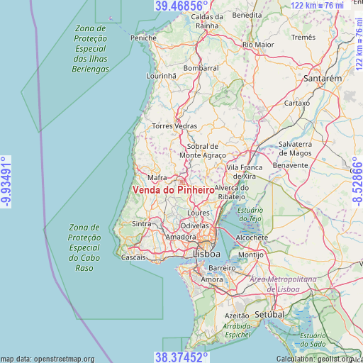
Venda do Pinheiro GPS coordinates[2]
38° 55' 25.14" North, 9° 13' 54.408" West
| Map corner | latitude | longitude |
|---|---|---|
| Upper-left | 39.46856°, | -9.93491° |
| Center: | 38.92365°, | -9.23178° |
| Lower-right: | 38.37452°, | -8.52866° |
| Map W x H: | 121.6×121.6 km | = 75.6×75.6mi |
| max Lat: | 42.11337° ⇑66.2% North |
| Venda do Pinheiro: | 38.92365° |
| min Lat: | ⇓33.8% South 32.6448° |
| min Long | Venda do Pinhei | max Long |
| -31.17847° | -9.23178° | -6.27308° |
| W 16.2%⇐ | ⇒83.8% E |
Elevation
Elevation of Venda do Pinheiro is 263 m = 863 ft, and this is 86 m = 282 ft above average elevation for this country.
| Max E: |
1008 m = 3307 ft | 21.7% |
| Venda do Pinheiro | 263 m 863 ft | |
| Avg. | 177 m = 581 ft | |
Min E: |
-128 m = -420 ft | 78.3% |
See also: Portugal elevation on elevation.city.
Geographical zone
Venda do Pinheiro is located in North temperate zone (between Tropic of Cancer and the Arctic Circle). Distance of this Northern Tropic circle is 1722 km =1070 mi to South.| Distance of | km | miles | from Venda do Pinheiro |
|---|---|---|---|
| North Pole | 5679.2 | 3528.9 | to North |
| Arctic Circle | 3073.3 | 1909.7 | to North |
| Tropic Cancer | 1722 | 1070 | to South |
| Equator | 4327.9 | 2689.2 | to South |


Nearby cities:
15 places around Venda do Pinheiro: (largest is in red/bold)
• Almargem
9.5 km =5.9 mi,  202°
202°
• Arranhó
9 km =5.6 mi,  68°
68°
• Arruda dos Vinhos
14.9 km =9.3 mi,  63°
63°
• Bucelas
10.1 km =6.3 mi,  103°
103°
• Caneças
12.3 km =7.6 mi,  177°
177°
• Loures
11.7 km =7.3 mi,  152°
152°
• Mafra
8.4 km =5.2 mi,  280°
280°
• Malveira
2.4 km =1.5 mi,  292°
292°
• Milharado
3.9 km =2.4 mi,  47°
47°
• Pero Pinheiro
10.8 km =6.7 mi,  227°
227°
• Ramada
13.9 km =8.6 mi,  164°
164°
• Santa Iria da Azóia
14.7 km =9.1 mi,  128°
128°
• Santo Antão do Tojal
11.3 km =7 mi,  135°
135°
• Sobral de Monte Agraço
12.8 km =8 mi,  33°
33°
• Vialonga
14.5 km =9 mi,  113°
113°
Sources, notices
• [Note1] Compared only with cities in Portugal existing in our database
• [Src1] Map data: © OpenStreetMap contributors (CC-BY-SA)
• [Src2] Other city data from geonames.org with taken over terms of usage.
• [Src3] Geographical zone / Annual Mean Temperature by Robert A. Rohde @ Wikipedia
