Caldas de Vizela geodata
Caldas de Vizela (Braga) is a populated place; located in Portugal in Europe/Lisbon (GMT+1) time zone. With population of 10,239 people, there are 214 cities with bigger population in this country. Compared to other cities in Portugal, 86.5% of cities are located further ↓South; 68.4% of cities are located further ←West and 64.1% of cities have lower elevation than Caldas de Vizela. Note1


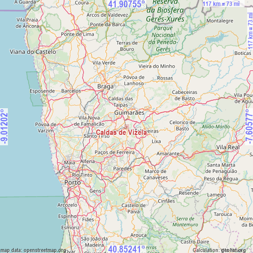
Caldas de Vizela GPS coordinates[2]
41° 22' 55.632" North, 8° 18' 32.04" West
| Map corner | latitude | longitude |
|---|---|---|
| Upper-left | 41.90755°, | -9.01202° |
| Center: | 41.38212°, | -8.3089° |
| Lower-right: | 40.85241°, | -7.60577° |
| Map W x H: | 117.3×117.3 km | = 72.9×72.9mi |
| max Lat: | 42.11337° ⇑13.5% North |
| Caldas de Vizela: | 41.38212° |
| min Lat: | ⇓86.5% South 32.6448° |
| min Long | Caldas de Vizel | max Long |
| -31.17847° | -8.3089° | -6.27308° |
| W 68.4%⇐ | ⇒31.6% E |
Elevation
Elevation of Caldas de Vizela is 174 m = 571 ft, and this is 3 m = 10 ft below average elevation for this country.
| Max E: |
1008 m = 3307 ft | 35.9% |
| Avg. | 177 m = 581 ft | |
| Caldas de Vizela | 174 m = 571 ft | |
Min E: |
-128 m = -420 ft | 64.1% |
See also: Portugal elevation on elevation.city.
Geographical zone
Caldas de Vizela is located in North temperate zone (between Tropic of Cancer and the Arctic Circle). Distance of this Northern Tropic circle is 1995.3 km =1239.8 mi to South.| Distance of | km | miles | from Caldas de Vizela |
|---|---|---|---|
| North Pole | 5405.8 | 3359 | to North |
| Arctic Circle | 2799.9 | 1739.8 | to North |
| Tropic Cancer | 1995.3 | 1239.8 | to South |
| Equator | 4601.3 | 2859.1 | to South |


Nearby cities:
15 places around Caldas de Vizela: (largest is in red/bold)
• Barrosas
3.1 km =1.9 mi,  165°
165°
• Candoso
5.2 km =3.2 mi,  348°
348°
• Guimarães
7 km =4.3 mi,  8°
8°
• Lordelo
6 km =3.7 mi,  261°
261°
• Lustosa
4.6 km =2.9 mi,  188°
188°
• Moreira de Conegos
2.6 km =1.6 mi,  281°
281°
• Negrelos
8.5 km =5.3 mi,  244°
244°
• Riba de Ave
6.7 km =4.2 mi, 283°
• Selho
5.2 km =3.2 mi,  323°
323°
• Serzedelo
5.4 km =3.4 mi,  293°
293°
• Serzedo
7.1 km =4.4 mi,  69°
69°
• Urgeses
5.1 km =3.2 mi, 10°
• Vilarinho
3.1 km =1.9 mi,  216°
216°
• Vizela
3.9 km =2.4 mi,  75°
75°
• Vizela
5 km =3.1 mi,  89°
89°
Sources, notices
• [Note1] Compared only with cities in Portugal existing in our database
• [Src1] Map data: © OpenStreetMap contributors (CC-BY-SA)
• [Src2] Other city data from geonames.org with taken over terms of usage.
• [Src3] Geographical zone / Annual Mean Temperature by Robert A. Rohde @ Wikipedia
