Serzedo geodata
Serzedo (Braga) is a populated place; located in Portugal in Europe/Lisbon (GMT+1) time zone. With population of 8,000 people, there are 278 cities with bigger population in this country. Compared to other cities in Portugal, 88.1% of cities are located further ↓South; 72.2% of cities are located further ←West and 64.5% of cities have lower elevation than Serzedo. Note1


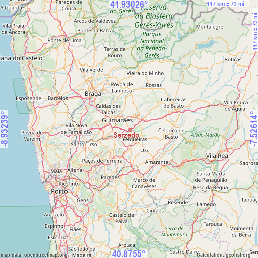
Serzedo GPS coordinates[2]
41° 24' 18.072" North, 8° 13' 45.336" West
| Map corner | latitude | longitude |
|---|---|---|
| Upper-left | 41.93026°, | -8.93239° |
| Center: | 41.40502°, | -8.22926° |
| Lower-right: | 40.8755°, | -7.52614° |
| Map W x H: | 117.3×117.3 km | = 72.9×72.9mi |
| max Lat: | 42.11337° ⇑11.9% North |
| Serzedo: | 41.40502° |
| min Lat: | ⇓88.1% South 32.6448° |
| min Long | Serzedo | max Long |
| -31.17847° | -8.22926° | -6.27308° |
| W 72.2%⇐ | ⇒27.8% E |
Elevation
Elevation of Serzedo is 175 m = 574 ft, and this is 2 m = 7 ft below average elevation for this country.
| Max E: |
1008 m = 3307 ft | 35.5% |
| Avg. | 177 m = 581 ft | |
| Serzedo | 175 m = 574 ft | |
Min E: |
-128 m = -420 ft | 64.5% |
See also: Portugal elevation on elevation.city.
Geographical zone
Serzedo is located in North temperate zone (between Tropic of Cancer and the Arctic Circle). Distance of this Northern Tropic circle is 1997.9 km =1241.4 mi to South.| Distance of | km | miles | from Serzedo |
|---|---|---|---|
| North Pole | 5403.3 | 3357.5 | to North |
| Arctic Circle | 2797.4 | 1738.2 | to North |
| Tropic Cancer | 1997.9 | 1241.4 | to South |
| Equator | 4603.8 | 2860.7 | to South |


Nearby cities:
15 places around Serzedo: (largest is in red/bold)
• Arões
5.8 km =3.6 mi,  12°
12°
• Barrosas
8 km =5 mi,  226°
226°
• Caldas de Vizela
7.1 km =4.4 mi,  249°
249°
• Candoso
8.1 km =5 mi,  288°
288°
• Fafe
6.9 km =4.3 mi,  42°
42°
• Felgueiras
5.1 km =3.2 mi,  144°
144°
• Guimarães
7.1 km =4.4 mi,  308°
308°
• Lustosa
10.2 km =6.3 mi, 225°
• Margaride
5.1 km =3.2 mi,  151°
151°
• Moreira de Conegos
9.4 km =5.8 mi,  257°
257°
• Selho
9.9 km =6.2 mi,  279°
279°
• Urgeses
6.2 km =3.9 mi, 293°
• Vilarinho
9.9 km =6.2 mi,  239°
239°
• Vizela
3 km =1.9 mi,  213°
213°
• Vizela
3.3 km =2.1 mi, 241°
Sources, notices
• [Note1] Compared only with cities in Portugal existing in our database
• [Src1] Map data: © OpenStreetMap contributors (CC-BY-SA)
• [Src2] Other city data from geonames.org with taken over terms of usage.
• [Src3] Geographical zone / Annual Mean Temperature by Robert A. Rohde @ Wikipedia
