Selho geodata
Selho (Braga) is a populated place; located in Portugal in Europe/Lisbon (GMT+1) time zone. With population of 10,223 people, there are 215 cities with bigger population in this country. Compared to other cities in Portugal, 88.9% of cities are located further ↓South; 66.4% of cities are located further ←West and 65.4% of cities have lower elevation than Selho. Note1


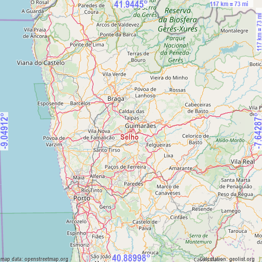
Selho GPS coordinates[2]
41° 25' 9.768" North, 8° 20' 45.564" West
| Map corner | latitude | longitude |
|---|---|---|
| Upper-left | 41.9445°, | -9.04912° |
| Center: | 41.41938°, | -8.34599° |
| Lower-right: | 40.88998°, | -7.64287° |
| Map W x H: | 117.3×117.3 km | = 72.9×72.9mi |
| max Lat: | 42.11337° ⇑11.1% North |
| Selho: | 41.41938° |
| min Lat: | ⇓88.9% South 32.6448° |
| min Long | Selho | max Long |
| -31.17847° | -8.34599° | -6.27308° |
| W 66.4%⇐ | ⇒33.6% E |
Elevation
Elevation of Selho is 180 m = 591 ft, and this is 3 m = 10 ft above average elevation for this country.
| Max E: |
1008 m = 3307 ft | 34.6% |
| Selho | 180 m 591 ft | |
| Avg. | 177 m = 581 ft | |
Min E: |
-128 m = -420 ft | 65.4% |
See also: Portugal elevation on elevation.city.
Geographical zone
Selho is located in North temperate zone (between Tropic of Cancer and the Arctic Circle). Distance of this Northern Tropic circle is 1999.5 km =1242.4 mi to South.| Distance of | km | miles | from Selho |
|---|---|---|---|
| North Pole | 5401.7 | 3356.5 | to North |
| Arctic Circle | 2795.8 | 1737.2 | to North |
| Tropic Cancer | 1999.5 | 1242.4 | to South |
| Equator | 4605.4 | 2861.7 | to South |


Nearby cities:
15 places around Selho: (largest is in red/bold)
• Brito
4.5 km =2.8 mi,  343°
343°
• Caldas das Taipas
7.3 km =4.5 mi,  358°
358°
• Caldas de Vizela
5.2 km =3.2 mi,  143°
143°
• Candoso
2.2 km =1.4 mi,  65°
65°
• Guimarães
5 km =3.1 mi,  56°
56°
• Joane
5.6 km =3.5 mi,  292°
292°
• Lordelo
5.8 km =3.6 mi,  209°
209°
• Moreira de Conegos
3.7 km =2.3 mi,  171°
171°
• Ponte
5.8 km =3.6 mi,  13°
13°
• Riba de Ave
4.3 km =2.7 mi,  233°
233°
• Ronfe
4 km =2.5 mi,  307°
307°
• Serzedelo
2.8 km =1.7 mi,  223°
223°
• Urgeses
4.1 km =2.5 mi,  77°
77°
• Vilarinho
6.8 km =4.2 mi, 169°
• Vizela
7.5 km =4.7 mi,  114°
114°
Sources, notices
• [Note1] Compared only with cities in Portugal existing in our database
• [Src1] Map data: © OpenStreetMap contributors (CC-BY-SA)
• [Src2] Other city data from geonames.org with taken over terms of usage.
• [Src3] Geographical zone / Annual Mean Temperature by Robert A. Rohde @ Wikipedia
