Guimarães geodata
Guimarães (Braga) is a seat of a second-order administrative division; located in Portugal in Europe/Lisbon (GMT+1) time zone. With population of 40,604 people, there are 28 cities with bigger population in this country. Compared to other cities in Portugal, 89.8% of cities are located further ↓South; 69.3% of cities are located further ←West and 67.5% of cities have lower elevation than Guimarães. Note1


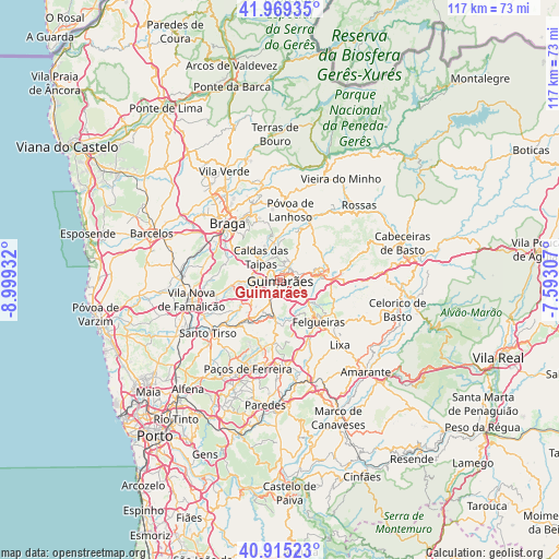
Guimarães GPS coordinates[2]
41° 26' 39.948" North, 8° 17' 46.284" West
| Map corner | latitude | longitude |
|---|---|---|
| Upper-left | 41.96935°, | -8.99932° |
| Center: | 41.44443°, | -8.29619° |
| Lower-right: | 40.91523°, | -7.59307° |
| Map W x H: | 117.2×117.2 km | = 72.8×72.8mi |
| max Lat: | 42.11337° ⇑10.2% North |
| Guimarães: | 41.44443° |
| min Lat: | ⇓89.8% South 32.6448° |
| min Long | Guimarães | max Long |
| -31.17847° | -8.29619° | -6.27308° |
| W 69.3%⇐ | ⇒30.7% E |
Elevation
Elevation of Guimarães is 189 m = 620 ft, and this is 12 m = 39 ft above average elevation for this country.
| Max E: |
1008 m = 3307 ft | 32.5% |
| Guimarães | 189 m 620 ft | |
| Avg. | 177 m = 581 ft | |
Min E: |
-128 m = -420 ft | 67.5% |
See also: Guimarães elevation on elevation.city.
Geographical zone
Guimarães is located in North temperate zone (between Tropic of Cancer and the Arctic Circle). Distance of this Northern Tropic circle is 2002.3 km =1244.2 mi to South.| Distance of | km | miles | from Guimarães |
|---|---|---|---|
| North Pole | 5398.9 | 3354.7 | to North |
| Arctic Circle | 2793 | 1735.5 | to North |
| Tropic Cancer | 2002.3 | 1244.2 | to South |
| Equator | 4608.2 | 2863.4 | to South |


Nearby cities:
15 places around Guimarães: (largest is in red/bold)
• Arões
6.9 km =4.3 mi,  79°
79°
• Brito
5.6 km =3.5 mi,  285°
285°
• Caldas das Taipas
6.2 km =3.9 mi,  315°
315°
• Caldas de Vizela
7 km =4.3 mi,  188°
188°
• Candoso
2.8 km =1.7 mi,  228°
228°
• Moreira de Conegos
7.4 km =4.6 mi,  209°
209°
• Ponte
4 km =2.5 mi, 315°
• Riba de Ave
9.3 km =5.8 mi, 234°
• Ronfe
7.3 km =4.5 mi,  267°
267°
• Selho
5 km =3.1 mi,  236°
236°
• Serzedelo
7.7 km =4.8 mi, 231°
• Serzedo
7.1 km =4.4 mi,  128°
128°
• Urgeses
1.9 km =1.2 mi,  184°
184°
• Vizela
6.5 km =4 mi,  155°
155°
• Vizela
7.9 km =4.9 mi,  150°
150°
Sources, notices
• [Note1] Compared only with cities in Portugal existing in our database
• [Src1] Map data: © OpenStreetMap contributors (CC-BY-SA)
• [Src2] Other city data from geonames.org with taken over terms of usage.
• [Src3] Geographical zone / Annual Mean Temperature by Robert A. Rohde @ Wikipedia
