Santa Ovaia geodata
Santa Ovaia (Coimbra) is a populated place; located in Portugal in Europe/Lisbon (GMT+1) time zone. With population of 952 people, there are 762 cities with bigger population in this country. Compared to other cities in Portugal, 58% of cities are located further ↓South; 83.1% of cities are located further ←West and 90.7% of cities have lower elevation than Santa Ovaia. Note1


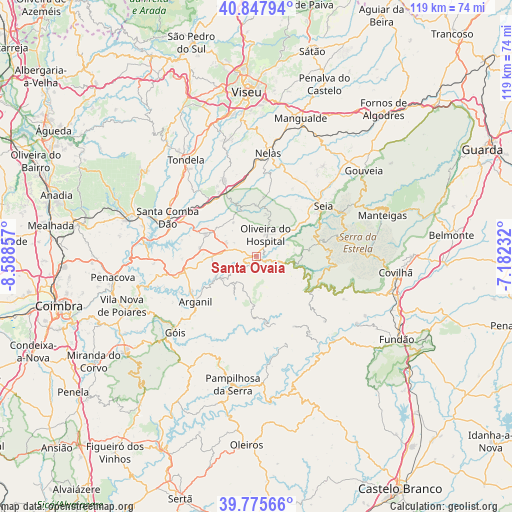
Santa Ovaia GPS coordinates[2]
40° 18' 50.148" North, 7° 53' 7.62" West
| Map corner | latitude | longitude |
|---|---|---|
| Upper-left | 40.84794°, | -8.58857° |
| Center: | 40.31393°, | -7.88545° |
| Lower-right: | 39.77566°, | -7.18232° |
| Map W x H: | 119.2×119.2 km | = 74.1×74.1mi |
| max Lat: | 42.11337° ⇑42% North |
| Santa Ovaia: | 40.31393° |
| min Lat: | ⇓58% South 32.6448° |
| min Long | Santa Ovaia | max Long |
| -31.17847° | -7.88545° | -6.27308° |
| W 83.1%⇐ | ⇒16.9% E |
Elevation
Elevation of Santa Ovaia is 485 m = 1591 ft, and this is 308 m = 1010 ft above average elevation for this country.
| Max E: |
1008 m = 3307 ft | 9.3% |
| Santa Ovaia | 485 m 1591 ft | |
| Avg. | 177 m = 581 ft | |
Min E: |
-128 m = -420 ft | 90.7% |
See also: Portugal elevation on elevation.city.
Geographical zone
Santa Ovaia is located in North temperate zone (between Tropic of Cancer and the Arctic Circle). Distance of this Northern Tropic circle is 1876.6 km =1166.1 mi to South.| Distance of | km | miles | from Santa Ovaia |
|---|---|---|---|
| North Pole | 5524.6 | 3432.8 | to North |
| Arctic Circle | 2918.7 | 1813.6 | to North |
| Tropic Cancer | 1876.6 | 1166.1 | to South |
| Equator | 4482.5 | 2785.3 | to South |


Nearby cities:
15 places around Santa Ovaia: (largest is in red/bold)
• Arganil
17.8 km =11.1 mi,  233°
233°
• Avô
2.8 km =1.7 mi,  212°
212°
• Barroca Grande
21.2 km =13.2 mi,  146°
146°
• Cabanas de Viriato
19.6 km =12.2 mi,  337°
337°
• Canas de Senhorim
20.7 km =12.9 mi,  356°
356°
• Carregal do Sal
16.4 km =10.2 mi,  323°
323°
• Lapa do Lobo
18.3 km =11.4 mi,  351°
351°
• Loriga
16.7 km =10.4 mi,  85°
85°
• Oliveira do Hospital
5.7 km =3.5 mi,  21°
21°
• Seia
18.7 km =11.6 mi,  53°
53°
• São Jorge da Beira
19.1 km =11.9 mi, 147°
• São João de Areias
17.5 km =10.9 mi,  297°
297°
• São Romão
17.4 km =10.8 mi,  56°
56°
• Tábua
13.3 km =8.3 mi,  293°
293°
• Vide
8.8 km =5.5 mi,  103°
103°
Sources, notices
• [Note1] Compared only with cities in Portugal existing in our database
• [Src1] Map data: © OpenStreetMap contributors (CC-BY-SA)
• [Src2] Other city data from geonames.org with taken over terms of usage.
• [Src3] Geographical zone / Annual Mean Temperature by Robert A. Rohde @ Wikipedia
