Seia geodata
Seia (Guarda) is a seat of a second-order administrative division; located in Portugal in Europe/Lisbon (GMT+1) time zone. With population of 7,082 people, there are 318 cities with bigger population in this country. Compared to other cities in Portugal, 60.1% of cities are located further ↓South; 87.6% of cities are located further ←West and 92.8% of cities have lower elevation than Seia. Note1


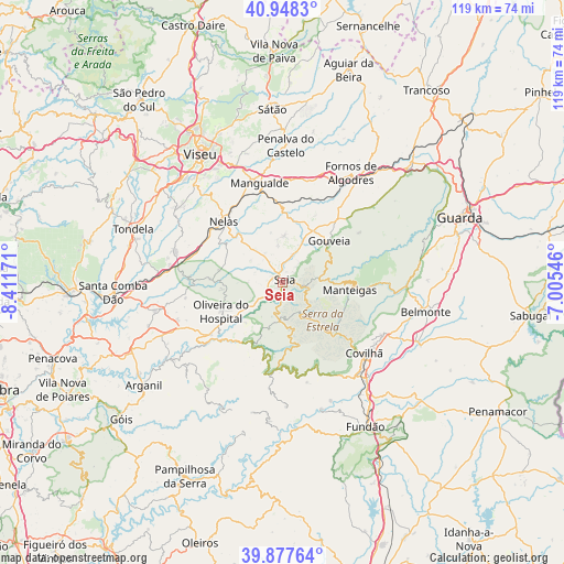
Seia GPS coordinates[2]
40° 24' 54.36" North, 7° 42' 30.924" West
| Map corner | latitude | longitude |
|---|---|---|
| Upper-left | 40.9483°, | -8.41171° |
| Center: | 40.4151°, | -7.70859° |
| Lower-right: | 39.87764°, | -7.00546° |
| Map W x H: | 119×119 km | = 73.9×73.9mi |
| max Lat: | 42.11337° ⇑39.9% North |
| Seia: | 40.4151° |
| min Lat: | ⇓60.1% South 32.6448° |
| min Long | Seia | max Long |
| -31.17847° | -7.70859° | -6.27308° |
| W 87.6%⇐ | ⇒12.4% E |
Elevation
Elevation of Seia is 551 m = 1808 ft, and this is 374 m = 1227 ft above average elevation for this country.
| Max E: |
1008 m = 3307 ft | 7.2% |
| Seia | 551 m 1808 ft | |
| Avg. | 177 m = 581 ft | |
Min E: |
-128 m = -420 ft | 92.8% |
See also: Portugal elevation on elevation.city.
Geographical zone
Seia is located in North temperate zone (between Tropic of Cancer and the Arctic Circle). Distance of this Northern Tropic circle is 1887.8 km =1173 mi to South.| Distance of | km | miles | from Seia |
|---|---|---|---|
| North Pole | 5513.3 | 3425.8 | to North |
| Arctic Circle | 2907.4 | 1806.6 | to North |
| Tropic Cancer | 1887.8 | 1173 | to South |
| Equator | 4493.7 | 2792.3 | to South |


Nearby cities:
15 places around Seia: (largest is in red/bold)
• Avô
21.4 km =13.3 mi,  230°
230°
• Cabanas de Viriato
23.5 km =14.6 mi,  286°
286°
• Canas de Senhorim
18.7 km =11.6 mi,  300°
300°
• Covilhã
22.8 km =14.2 mi,  130°
130°
• Lapa do Lobo
19 km =11.8 mi, 290°
• Loriga
10.1 km =6.3 mi,  170°
170°
• Mangualde
21.5 km =13.4 mi,  348°
348°
• Manteigas
14.4 km =8.9 mi,  95°
95°
• Mesquitela
19.2 km =11.9 mi, 350°
• Nelas
17.8 km =11.1 mi,  317°
317°
• Oliveira do Hospital
14.1 km =8.8 mi,  245°
245°
• Santa Ovaia
18.7 km =11.6 mi, 233°
• São Romão
1.6 km =1 mi,  198°
198°
• Teixoso
24 km =14.9 mi,  117°
117°
• Vide
14.8 km =9.2 mi,  205°
205°
Sources, notices
• [Note1] Compared only with cities in Portugal existing in our database
• [Src1] Map data: © OpenStreetMap contributors (CC-BY-SA)
• [Src2] Other city data from geonames.org with taken over terms of usage.
• [Src3] Geographical zone / Annual Mean Temperature by Robert A. Rohde @ Wikipedia
