Loriga geodata
Loriga (Guarda) is a populated place; located in Portugal in Europe/Lisbon (GMT+1) time zone. With population of 1,053 people, there are 742 cities with bigger population in this country. Compared to other cities in Portugal, 58.5% of cities are located further ↓South; 88.1% of cities are located further ←West and 98.6% of cities have lower elevation than Loriga. Note1


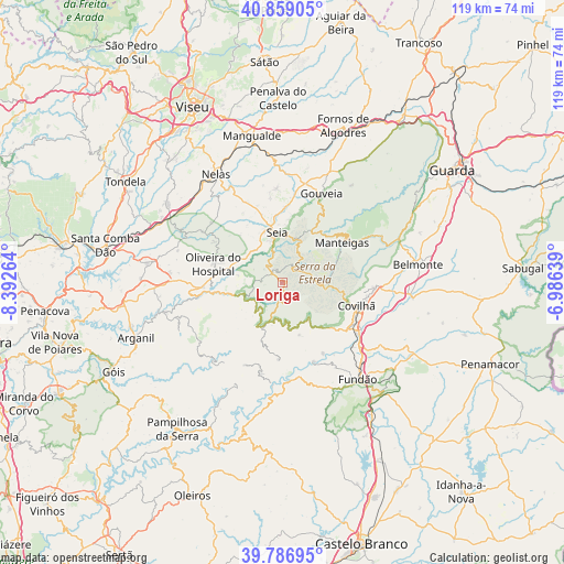
Loriga GPS coordinates[2]
40° 19' 30.468" North, 7° 41' 22.272" West
| Map corner | latitude | longitude |
|---|---|---|
| Upper-left | 40.85905°, | -8.39264° |
| Center: | 40.32513°, | -7.68952° |
| Lower-right: | 39.78695°, | -6.98639° |
| Map W x H: | 119.2×119.2 km | = 74.1×74.1mi |
| max Lat: | 42.11337° ⇑41.5% North |
| Loriga: | 40.32513° |
| min Lat: | ⇓58.5% South 32.6448° |
| min Long | Loriga | max Long |
| -31.17847° | -7.68952° | -6.27308° |
| W 88.1%⇐ | ⇒11.9% E |
Elevation
Elevation of Loriga is 755 m = 2477 ft, and this is 578 m = 1896 ft above average elevation for this country.
| Max E: |
1008 m = 3307 ft | 1.4% |
| Loriga | 755 m 2477 ft | |
| Avg. | 177 m = 581 ft | |
Min E: |
-128 m = -420 ft | 98.6% |
See also: Portugal elevation on elevation.city.
Geographical zone
Loriga is located in North temperate zone (between Tropic of Cancer and the Arctic Circle). Distance of this Northern Tropic circle is 1877.8 km =1166.8 mi to South.| Distance of | km | miles | from Loriga |
|---|---|---|---|
| North Pole | 5523.3 | 3432 | to North |
| Arctic Circle | 2917.4 | 1812.8 | to North |
| Tropic Cancer | 1877.8 | 1166.8 | to South |
| Equator | 4483.7 | 2786 | to South |


Nearby cities:
15 places around Loriga: (largest is in red/bold)
• Aldeia de Joanes
25.4 km =15.8 mi,  144°
144°
• Avô
18.4 km =11.4 mi,  258°
258°
• Barco
18.2 km =11.3 mi,  157°
157°
• Barroca Grande
19.7 km =12.2 mi,  194°
194°
• Covilhã
16.4 km =10.2 mi,  107°
107°
• Manteigas
15.3 km =9.5 mi,  55°
55°
• Oliveira do Hospital
15 km =9.3 mi,  285°
285°
• Santa Ovaia
16.7 km =10.4 mi,  265°
265°
• Seia
10.1 km =6.3 mi,  350°
350°
• São Jorge da Beira
18.4 km =11.4 mi,  199°
199°
• São Romão
8.7 km =5.4 mi, 345°
• Teixoso
19.7 km =12.2 mi,  93°
93°
• Unhais-o-Velho
23.9 km =14.9 mi,  205°
205°
• Vales do Rio
18.4 km =11.4 mi, 138°
• Vide
8.7 km =5.4 mi,  247°
247°
Sources, notices
• [Note1] Compared only with cities in Portugal existing in our database
• [Src1] Map data: © OpenStreetMap contributors (CC-BY-SA)
• [Src2] Other city data from geonames.org with taken over terms of usage.
• [Src3] Geographical zone / Annual Mean Temperature by Robert A. Rohde @ Wikipedia
