Covilhã geodata
Covilhã (Castelo Branco) is a populated place; located in Portugal in Europe/Lisbon (GMT+1) time zone. With population of 17,610 people, there are 117 cities with bigger population in this country. Compared to other cities in Portugal, 57.4% of cities are located further ↓South; 91.9% of cities are located further ←West and 92.2% of cities have lower elevation than Covilhã. Note1


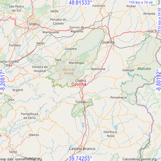
Covilhã GPS coordinates[2]
40° 16' 51.816" North, 7° 30' 18.144" West
| Map corner | latitude | longitude |
|---|---|---|
| Upper-left | 40.81533°, | -8.20817° |
| Center: | 40.28106°, | -7.50504° |
| Lower-right: | 39.74253°, | -6.80192° |
| Map W x H: | 119.3×119.3 km | = 74.1×74.1mi |
| max Lat: | 42.11337° ⇑42.6% North |
| Covilhã: | 40.28106° |
| min Lat: | ⇓57.4% South 32.6448° |
| min Long | Covilhã | max Long |
| -31.17847° | -7.50504° | -6.27308° |
| W 91.9%⇐ | ⇒8.1% E |
Elevation
Elevation of Covilhã is 534 m = 1752 ft, and this is 357 m = 1171 ft above average elevation for this country.
| Max E: |
1008 m = 3307 ft | 7.8% |
| Covilhã | 534 m 1752 ft | |
| Avg. | 177 m = 581 ft | |
Min E: |
-128 m = -420 ft | 92.2% |
See also: Portugal elevation on elevation.city.
Geographical zone
Covilhã is located in North temperate zone (between Tropic of Cancer and the Arctic Circle). Distance of this Northern Tropic circle is 1872.9 km =1163.8 mi to South.| Distance of | km | miles | from Covilhã |
|---|---|---|---|
| North Pole | 5528.2 | 3435.1 | to North |
| Arctic Circle | 2922.3 | 1815.8 | to North |
| Tropic Cancer | 1872.9 | 1163.8 | to South |
| Equator | 4478.8 | 2783 | to South |


Nearby cities:
15 places around Covilhã: (largest is in red/bold)
• Aldeia de Joanes
15.8 km =9.8 mi,  183°
183°
• Barco
14.8 km =9.2 mi,  216°
216°
• Barroca Grande
25.1 km =15.6 mi,  235°
235°
• Belmonte
15.9 km =9.9 mi,  56°
56°
• Famalicão
21 km =13 mi,  30°
30°
• Fundão
15.7 km =9.8 mi, 178°
• Loriga
16.4 km =10.2 mi,  287°
287°
• Manteigas
13.9 km =8.6 mi,  347°
347°
• Seia
22.8 km =14.2 mi,  310°
310°
• São Jorge da Beira
25.2 km =15.7 mi, 240°
• São Romão
22.2 km =13.8 mi, 306°
• Teixoso
5.5 km =3.4 mi,  47°
47°
• Unhais-o-Velho
30.8 km =19.1 mi, 237°
• Vales do Rio
9.5 km =5.9 mi,  201°
201°
• Vide
23.7 km =14.7 mi,  273°
273°
Sources, notices
• [Note1] Compared only with cities in Portugal existing in our database
• [Src1] Map data: © OpenStreetMap contributors (CC-BY-SA)
• [Src2] Other city data from geonames.org with taken over terms of usage.
• [Src3] Geographical zone / Annual Mean Temperature by Robert A. Rohde @ Wikipedia
