Manteigas geodata
Manteigas (Guarda) is a seat of a second-order administrative division; located in Portugal in Europe/Lisbon (GMT+1) time zone. With population of 3,900 people, there are 531 cities with bigger population in this country. Compared to other cities in Portugal, 60% of cities are located further ↓South; 91.1% of cities are located further ←West and 99% of cities have lower elevation than Manteigas. Note1


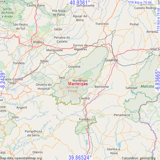
Manteigas GPS coordinates[2]
40° 24' 10.08" North, 7° 32' 23.172" West
| Map corner | latitude | longitude |
|---|---|---|
| Upper-left | 40.9361°, | -8.2429° |
| Center: | 40.4028°, | -7.53977° |
| Lower-right: | 39.86524°, | -6.83665° |
| Map W x H: | 119.1×119.1 km | = 74×74mi |
| max Lat: | 42.11337° ⇑40% North |
| Manteigas: | 40.4028° |
| min Lat: | ⇓60% South 32.6448° |
| min Long | Manteigas | max Long |
| -31.17847° | -7.53977° | -6.27308° |
| W 91.1%⇐ | ⇒8.9% E |
Elevation
Elevation of Manteigas is 794 m = 2605 ft, and this is 617 m = 2024 ft above average elevation for this country.
| Max E: |
1008 m = 3307 ft | 1% |
| Manteigas | 794 m 2605 ft | |
| Avg. | 177 m = 581 ft | |
Min E: |
-128 m = -420 ft | 99% |
See also: Portugal elevation on elevation.city.
Geographical zone
Manteigas is located in North temperate zone (between Tropic of Cancer and the Arctic Circle). Distance of this Northern Tropic circle is 1886.5 km =1172.2 mi to South.| Distance of | km | miles | from Manteigas |
|---|---|---|---|
| North Pole | 5514.7 | 3426.7 | to North |
| Arctic Circle | 2908.8 | 1807.4 | to North |
| Tropic Cancer | 1886.5 | 1172.2 | to South |
| Equator | 4492.4 | 2791.4 | to South |


Nearby cities:
15 places around Manteigas: (largest is in red/bold)
• Barco
26.1 km =16.2 mi,  192°
192°
• Belmonte
16.9 km =10.5 mi,  106°
106°
• Celorico da Beira
29 km =18 mi,  25°
25°
• Covilhã
13.9 km =8.6 mi,  167°
167°
• Famalicão
14.4 km =8.9 mi,  71°
71°
• Fornos de Algodres
25 km =15.5 mi,  359°
359°
• Guarda
27.6 km =17.1 mi,  57°
57°
• Loriga
15.3 km =9.5 mi,  235°
235°
• Mesquitela
26.8 km =16.7 mi,  319°
319°
• Oliveira do Hospital
27.5 km =17.1 mi,  260°
260°
• Seia
14.4 km =8.9 mi,  275°
275°
• São Romão
14.8 km =9.2 mi,  269°
269°
• Teixoso
12 km =7.5 mi,  144°
144°
• Vales do Rio
22.4 km =13.9 mi,  181°
181°
• Vide
23.9 km =14.9 mi, 239°
Sources, notices
• [Note1] Compared only with cities in Portugal existing in our database
• [Src1] Map data: © OpenStreetMap contributors (CC-BY-SA)
• [Src2] Other city data from geonames.org with taken over terms of usage.
• [Src3] Geographical zone / Annual Mean Temperature by Robert A. Rohde @ Wikipedia
