Barroca Grande geodata
Barroca Grande (Castelo Branco) is a populated place; located in Portugal in Europe/Lisbon (GMT+1) time zone. With population of 600 people, there are 812 cities with bigger population in this country. Compared to other cities in Portugal, 54.9% of cities are located further ↓South; 86.5% of cities are located further ←West and 96.8% of cities have lower elevation than Barroca Grande. Note1
Administrative division(s):
- Level 1: Castelo Branco
- Level 2: Covilhã
- Level 3: Aldeia de São Francisco de Assis


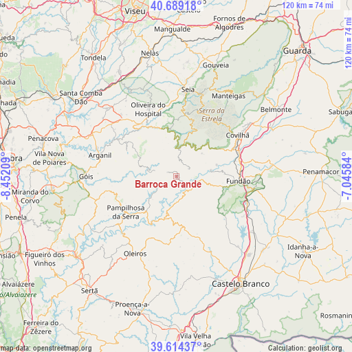
Barroca Grande GPS coordinates[2]
40° 9' 14.04" North, 7° 44' 56.292" West
| Map corner | latitude | longitude |
|---|---|---|
| Upper-left | 40.68918°, | -8.45209° |
| Center: | 40.1539°, | -7.74897° |
| Lower-right: | 39.61437°, | -7.04584° |
| Map W x H: | 119.5×119.5 km | = 74.3×74.3mi |
| max Lat: | 42.11337° ⇑45.1% North |
| Barroca Grande: | 40.1539° |
| min Lat: | ⇓54.9% South 32.6448° |
| min Long | Barroca Grande | max Long |
| -31.17847° | -7.74897° | -6.27308° |
| W 86.5%⇐ | ⇒13.5% E |
Elevation
Elevation of Barroca Grande is 695 m = 2280 ft, and this is 518 m = 1699 ft above average elevation for this country.
| Max E: |
1008 m = 3307 ft | 3.2% |
| Barroca Grande | 695 m 2280 ft | |
| Avg. | 177 m = 581 ft | |
Min E: |
-128 m = -420 ft | 96.8% |
See also: Portugal elevation on elevation.city.
Geographical zone
Barroca Grande is located in North temperate zone (between Tropic of Cancer and the Arctic Circle). Distance of this Northern Tropic circle is 1858.8 km =1155 mi to South.| Distance of | km | miles | from Barroca Grande |
|---|---|---|---|
| North Pole | 5542.4 | 3443.9 | to North |
| Arctic Circle | 2936.5 | 1824.7 | to North |
| Tropic Cancer | 1858.8 | 1155 | to South |
| Equator | 4464.7 | 2774.2 | to South |


Nearby cities:
15 places around Barroca Grande: (largest is in red/bold)
• Aldeia de Joanes
19.8 km =12.3 mi,  94°
94°
• Arganil
26.9 km =16.7 mi,  285°
285°
• Avô
20.2 km =12.6 mi,  319°
319°
• Barco
12.2 km =7.6 mi,  79°
79°
• Covilhã
25.1 km =15.6 mi,  55°
55°
• Fundão
21.1 km =13.1 mi, 94°
• Loriga
19.7 km =12.2 mi,  14°
14°
• Oliveira do Hospital
25 km =15.5 mi,  337°
337°
• Pampilhosa da Serra
21 km =13 mi,  235°
235°
• Santa Ovaia
21.2 km =13.2 mi,  326°
326°
• São Jorge da Beira
2.1 km =1.3 mi, 325°
• São Romão
27.6 km =17.1 mi, 6°
• Unhais-o-Velho
5.8 km =3.6 mi, 244°
• Vales do Rio
18.1 km =11.2 mi,  72°
72°
• Vide
16 km =9.9 mi,  349°
349°
Sources, notices
• [Note1] Compared only with cities in Portugal existing in our database
• [Src1] Map data: © OpenStreetMap contributors (CC-BY-SA)
• [Src2] Other city data from geonames.org with taken over terms of usage.
• [Src3] Geographical zone / Annual Mean Temperature by Robert A. Rohde @ Wikipedia
