Oliveira geodata
Oliveira (Braga) is a populated place; located in Portugal in Europe/Lisbon (GMT+1) time zone. With population of 6,222 people, there are 351 cities with bigger population in this country. Compared to other cities in Portugal, 91% of cities are located further ↓South; 56.7% of cities are located further ←West and 66.4% of cities have lower elevation than Oliveira. Note1


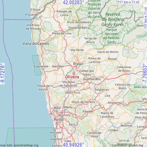
Oliveira GPS coordinates[2]
41° 28' 41.484" North, 8° 28' 10.74" West
| Map corner | latitude | longitude |
|---|---|---|
| Upper-left | 42.00283°, | -9.17278° |
| Center: | 41.47819°, | -8.46965° |
| Lower-right: | 40.94926°, | -7.76653° |
| Map W x H: | 117.1×117.1 km | = 72.8×72.8mi |
| max Lat: | 42.11337° ⇑9% North |
| Oliveira: | 41.47819° |
| min Lat: | ⇓91% South 32.6448° |
| min Long | Oliveira | max Long |
| -31.17847° | -8.46965° | -6.27308° |
| W 56.7%⇐ | ⇒43.3% E |
Elevation
Elevation of Oliveira is 184 m = 604 ft, and this is 7 m = 23 ft above average elevation for this country.
| Max E: |
1008 m = 3307 ft | 33.6% |
| Oliveira | 184 m 604 ft | |
| Avg. | 177 m = 581 ft | |
Min E: |
-128 m = -420 ft | 66.4% |
See also: Portugal elevation on elevation.city.
Geographical zone
Oliveira is located in North temperate zone (between Tropic of Cancer and the Arctic Circle). Distance of this Northern Tropic circle is 2006 km =1246.5 mi to South.| Distance of | km | miles | from Oliveira |
|---|---|---|---|
| North Pole | 5395.1 | 3352.4 | to North |
| Arctic Circle | 2789.2 | 1733.1 | to North |
| Tropic Cancer | 2006 | 1246.5 | to South |
| Equator | 4611.9 | 2865.7 | to South |


Nearby cities:
15 places around Oliveira: (largest is in red/bold)
• Arcos
6.3 km =3.9 mi,  39°
39°
• Aveleda
4.8 km =3 mi,  2°
2°
• Braga
9 km =5.6 mi,  27°
27°
• Brito
9.3 km =5.8 mi,  103°
103°
• Esporões
5.6 km =3.5 mi,  50°
50°
• Gondizalves
7.1 km =4.4 mi,  9°
9°
• Guisande
2.1 km =1.3 mi,  76°
76°
• Joane
6.7 km =4.2 mi,  130°
130°
• Lamas
4 km =2.5 mi, 47°
• Real
9.2 km =5.7 mi, 13°
• Ronfe
8.2 km =5.1 mi,  119°
119°
• Semelhe
8.5 km =5.3 mi, 3°
• Tebosa
1.3 km =0.8 mi,  291°
291°
• Vila Nova de Famalicão
8.9 km =5.5 mi,  208°
208°
• Vilaça
4.6 km =2.9 mi,  345°
345°
Sources, notices
• [Note1] Compared only with cities in Portugal existing in our database
• [Src1] Map data: © OpenStreetMap contributors (CC-BY-SA)
• [Src2] Other city data from geonames.org with taken over terms of usage.
• [Src3] Geographical zone / Annual Mean Temperature by Robert A. Rohde @ Wikipedia
