Esporões geodata
Esporões (Braga) is a populated place; located in Portugal in Europe/Lisbon (GMT+1) time zone. With population of 1,709 people, there are 674 cities with bigger population in this country. Compared to other cities in Portugal, 92.5% of cities are located further ↓South; 61.4% of cities are located further ←West and 73.3% of cities have lower elevation than Esporões. Note1


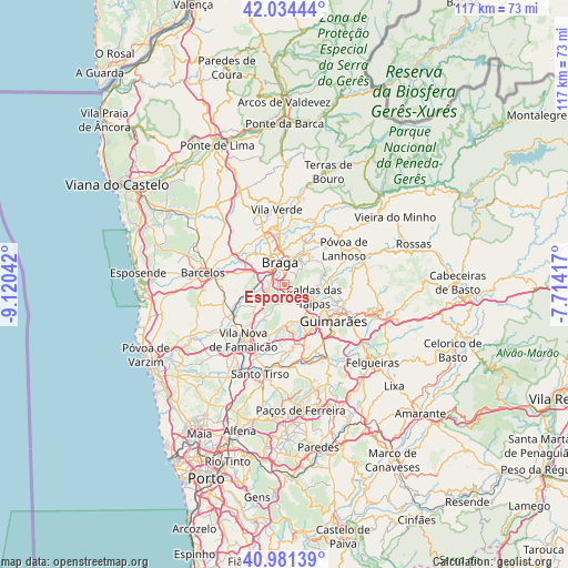
Esporões GPS coordinates[2]
41° 30' 36.216" North, 8° 25' 2.244" West
| Map corner | latitude | longitude |
|---|---|---|
| Upper-left | 42.03444°, | -9.12042° |
| Center: | 41.51006°, | -8.41729° |
| Lower-right: | 40.98139°, | -7.71417° |
| Map W x H: | 117.1×117.1 km | = 72.8×72.8mi |
| max Lat: | 42.11337° ⇑7.5% North |
| Esporões: | 41.51006° |
| min Lat: | ⇓92.5% South 32.6448° |
| min Long | Esporões | max Long |
| -31.17847° | -8.41729° | -6.27308° |
| W 61.4%⇐ | ⇒38.6% E |
Elevation
Elevation of Esporões is 221 m = 725 ft, and this is 44 m = 144 ft above average elevation for this country.
| Max E: |
1008 m = 3307 ft | 26.7% |
| Esporões | 221 m 725 ft | |
| Avg. | 177 m = 581 ft | |
Min E: |
-128 m = -420 ft | 73.3% |
See also: Portugal elevation on elevation.city.
Geographical zone
Esporões is located in North temperate zone (between Tropic of Cancer and the Arctic Circle). Distance of this Northern Tropic circle is 2009.6 km =1248.7 mi to South.| Distance of | km | miles | from Esporões |
|---|---|---|---|
| North Pole | 5391.6 | 3350.2 | to North |
| Arctic Circle | 2785.7 | 1731 | to North |
| Tropic Cancer | 2009.6 | 1248.7 | to South |
| Equator | 4615.5 | 2867.9 | to South |


Nearby cities:
15 places around Esporões: (largest is in red/bold)
• Arcos
1.4 km =0.9 mi,  344°
344°
• Aveleda
4.3 km =2.7 mi,  286°
286°
• Braga
4.5 km =2.8 mi,  357°
357°
• Brito
7.4 km =4.6 mi,  140°
140°
• Caldas das Taipas
6.4 km =4 mi,  116°
116°
• Frossos
6.8 km =4.2 mi, 335°
• Gondizalves
4.7 km =2.9 mi,  317°
317°
• Guisande
3.9 km =2.4 mi,  217°
217°
• Joane
7.9 km =4.9 mi,  174°
174°
• Lamas
1.7 km =1.1 mi,  240°
240°
• Oliveira
5.6 km =3.5 mi,  230°
230°
• Real
5.8 km =3.6 mi, 338°
• Semelhe
6.2 km =3.9 mi, 322°
• Tebosa
6.3 km =3.9 mi, 241°
• Vilaça
5.6 km =3.5 mi,  278°
278°
Sources, notices
• [Note1] Compared only with cities in Portugal existing in our database
• [Src1] Map data: © OpenStreetMap contributors (CC-BY-SA)
• [Src2] Other city data from geonames.org with taken over terms of usage.
• [Src3] Geographical zone / Annual Mean Temperature by Robert A. Rohde @ Wikipedia
