Lamas geodata
Lamas (Braga) is a populated place; located in Portugal in Europe/Lisbon (GMT+1) time zone. With population of 842 people, there are 778 cities with bigger population in this country. Compared to other cities in Portugal, 92.4% of cities are located further ↓South; 60% of cities are located further ←West and 60.3% of cities have lower elevation than Lamas. Note1


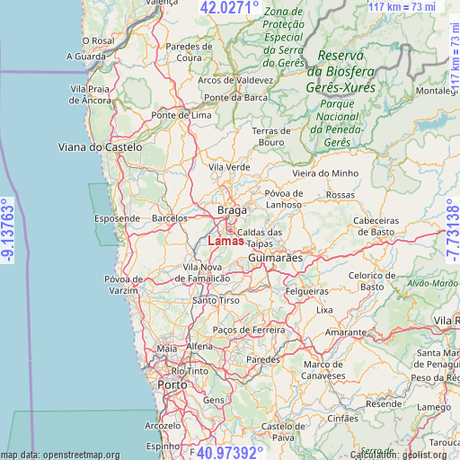
Lamas GPS coordinates[2]
41° 30' 9.54" North, 8° 26' 4.2" West
| Map corner | latitude | longitude |
|---|---|---|
| Upper-left | 42.0271°, | -9.13763° |
| Center: | 41.50265°, | -8.4345° |
| Lower-right: | 40.97392°, | -7.73138° |
| Map W x H: | 117.1×117.1 km | = 72.8×72.8mi |
| max Lat: | 42.11337° ⇑7.6% North |
| Lamas: | 41.50265° |
| min Lat: | ⇓92.4% South 32.6448° |
| min Long | Lamas | max Long |
| -31.17847° | -8.4345° | -6.27308° |
| W 60%⇐ | ⇒40% E |
Elevation
Elevation of Lamas is 156 m = 512 ft, and this is 21 m = 69 ft below average elevation for this country.
| Max E: |
1008 m = 3307 ft | 39.7% |
| Avg. | 177 m = 581 ft | |
| Lamas | 156 m = 512 ft | |
Min E: |
-128 m = -420 ft | 60.3% |
See also: Portugal elevation on elevation.city.
Geographical zone
Lamas is located in North temperate zone (between Tropic of Cancer and the Arctic Circle). Distance of this Northern Tropic circle is 2008.7 km =1248.1 mi to South.| Distance of | km | miles | from Lamas |
|---|---|---|---|
| North Pole | 5392.4 | 3350.7 | to North |
| Arctic Circle | 2786.5 | 1731.5 | to North |
| Tropic Cancer | 2008.7 | 1248.1 | to South |
| Equator | 4614.7 | 2867.4 | to South |


Nearby cities:
15 places around Lamas: (largest is in red/bold)
• Arcos
2.4 km =1.5 mi,  26°
26°
• Aveleda
3.4 km =2.1 mi,  307°
307°
• Braga
5.4 km =3.4 mi,  12°
12°
• Brito
7.9 km =4.9 mi,  128°
128°
• Caldas das Taipas
7.4 km =4.6 mi,  105°
105°
• Esporões
1.7 km =1.1 mi,  60°
60°
• Frossos
7.2 km =4.5 mi,  348°
348°
• Gondizalves
4.7 km =2.9 mi,  337°
337°
• Guisande
2.4 km =1.5 mi,  202°
202°
• Joane
7.4 km =4.6 mi,  162°
162°
• Oliveira
4 km =2.5 mi,  227°
227°
• Real
6.2 km =3.9 mi, 353°
• Semelhe
6.2 km =3.9 mi, 337°
• Tebosa
4.7 km =2.9 mi,  241°
241°
• Vilaça
4.4 km =2.7 mi,  292°
292°
Sources, notices
• [Note1] Compared only with cities in Portugal existing in our database
• [Src1] Map data: © OpenStreetMap contributors (CC-BY-SA)
• [Src2] Other city data from geonames.org with taken over terms of usage.
• [Src3] Geographical zone / Annual Mean Temperature by Robert A. Rohde @ Wikipedia
