Joane geodata
Joane (Braga) is a populated place; located in Portugal in Europe/Lisbon (GMT+1) time zone. With population of 7,869 people, there are 289 cities with bigger population in this country. Compared to other cities in Portugal, 89.5% of cities are located further ↓South; 62.2% of cities are located further ←West and 57.6% of cities have lower elevation than Joane. Note1


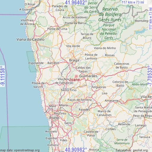
Joane GPS coordinates[2]
41° 26' 20.616" North, 8° 24' 30.456" West
| Map corner | latitude | longitude |
|---|---|---|
| Upper-left | 41.96402°, | -9.11158° |
| Center: | 41.43906°, | -8.40846° |
| Lower-right: | 40.90982°, | -7.70533° |
| Map W x H: | 117.2×117.2 km | = 72.8×72.8mi |
| max Lat: | 42.11337° ⇑10.5% North |
| Joane: | 41.43906° |
| min Lat: | ⇓89.5% South 32.6448° |
| min Long | Joane | max Long |
| -31.17847° | -8.40846° | -6.27308° |
| W 62.2%⇐ | ⇒37.8% E |
Elevation
Elevation of Joane is 139 m = 456 ft, and this is 38 m = 125 ft below average elevation for this country.
| Max E: |
1008 m = 3307 ft | 42.4% |
| Avg. | 177 m = 581 ft | |
| Joane | 139 m = 456 ft | |
Min E: |
-128 m = -420 ft | 57.6% |
See also: Portugal elevation on elevation.city.
Geographical zone
Joane is located in North temperate zone (between Tropic of Cancer and the Arctic Circle). Distance of this Northern Tropic circle is 2001.7 km =1243.8 mi to South.| Distance of | km | miles | from Joane |
|---|---|---|---|
| North Pole | 5399.5 | 3355.1 | to North |
| Arctic Circle | 2793.6 | 1735.9 | to North |
| Tropic Cancer | 2001.7 | 1243.8 | to South |
| Equator | 4607.6 | 2863 | to South |


Nearby cities:
15 places around Joane: (largest is in red/bold)
• Aves
7.6 km =4.7 mi,  181°
181°
• Brito
4.5 km =2.8 mi,  61°
61°
• Caldas das Taipas
7.1 km =4.4 mi,  44°
44°
• Candoso
7.3 km =4.5 mi,  99°
99°
• Esporões
7.9 km =4.9 mi,  354°
354°
• Guisande
5.8 km =3.6 mi,  327°
327°
• Lamas
7.4 km =4.6 mi,  342°
342°
• Lordelo
7.6 km =4.7 mi,  161°
161°
• Oliveira
6.7 km =4.2 mi,  310°
310°
• Ponte
7.4 km =4.6 mi, 61°
• Riba de Ave
5.1 km =3.2 mi, 159°
• Ronfe
2 km =1.2 mi,  82°
82°
• Selho
5.6 km =3.5 mi,  112°
112°
• Serzedelo
5.3 km =3.3 mi,  141°
141°
• Tebosa
7.9 km =4.9 mi, 307°
Sources, notices
• [Note1] Compared only with cities in Portugal existing in our database
• [Src1] Map data: © OpenStreetMap contributors (CC-BY-SA)
• [Src2] Other city data from geonames.org with taken over terms of usage.
• [Src3] Geographical zone / Annual Mean Temperature by Robert A. Rohde @ Wikipedia
