Monsanto geodata
Monsanto (Castelo Branco) is a populated place; located in Portugal in Europe/Lisbon (GMT+1) time zone. With population of 828 people, there are 780 cities with bigger population in this country. Compared to other cities in Portugal, 53.5% of cities are located further ↓South; 98.1% of cities are located further ←West and 96.3% of cities have lower elevation than Monsanto. Note1


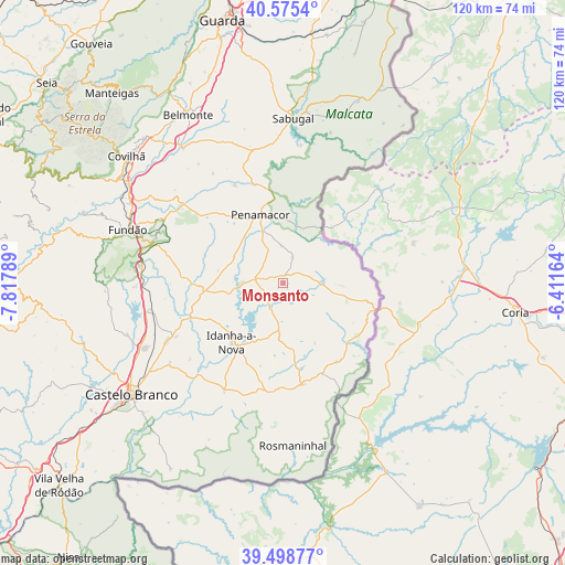
Monsanto GPS coordinates[2]
40° 2' 21.156" North, 7° 6' 53.172" West
| Map corner | latitude | longitude |
|---|---|---|
| Upper-left | 40.5754°, | -7.81789° |
| Center: | 40.03921°, | -7.11477° |
| Lower-right: | 39.49877°, | -6.41164° |
| Map W x H: | 119.7×119.7 km | = 74.4×74.4mi |
| max Lat: | 42.11337° ⇑46.5% North |
| Monsanto: | 40.03921° |
| min Lat: | ⇓53.5% South 32.6448° |
| min Long | Monsanto | max Long |
| -31.17847° | -7.11477° | -6.27308° |
| W 98.1%⇐ | ⇒1.9% E |
Elevation
Elevation of Monsanto is 655 m = 2149 ft, and this is 478 m = 1568 ft above average elevation for this country.
| Max E: |
1008 m = 3307 ft | 3.7% |
| Monsanto | 655 m 2149 ft | |
| Avg. | 177 m = 581 ft | |
Min E: |
-128 m = -420 ft | 96.3% |
See also: Portugal elevation on elevation.city.
Geographical zone
Monsanto is located in North temperate zone (between Tropic of Cancer and the Arctic Circle). Distance of this Northern Tropic circle is 1846 km =1147.1 mi to South.| Distance of | km | miles | from Monsanto |
|---|---|---|---|
| North Pole | 5555.1 | 3451.8 | to North |
| Arctic Circle | 2949.2 | 1832.5 | to North |
| Tropic Cancer | 1846 | 1147.1 | to South |
| Equator | 4451.9 | 2766.3 | to South |


Nearby cities:
15 places around Monsanto: (largest is in red/bold)
• Alcains
32.2 km =20 mi,  244°
244°
• Aldeia de Joanes
36 km =22.4 mi,  287°
287°
• Barco
44.6 km =27.7 mi, 289°
• Barroca Grande
55.4 km =34.4 mi,  283°
283°
• Belmonte
40.8 km =25.4 mi,  330°
330°
• Castelo Branco
40.1 km =24.9 mi,  233°
233°
• Covilhã
42.7 km =26.5 mi,  309°
309°
• Famalicão
50.1 km =31.1 mi, 333°
• Fundão
34.8 km =21.6 mi, 288°
• Idanha-a-Nova
16.8 km =10.4 mi,  219°
219°
• Manteigas
54.2 km =33.7 mi,  318°
318°
• Penamacor
15.2 km =9.4 mi,  342°
342°
• Sabugal
34.8 km =21.6 mi,  3°
3°
• Teixoso
42.2 km =26.2 mi, 316°
• Vales do Rio
40.8 km =25.4 mi,  296°
296°
Sources, notices
• [Note1] Compared only with cities in Portugal existing in our database
• [Src1] Map data: © OpenStreetMap contributors (CC-BY-SA)
• [Src2] Other city data from geonames.org with taken over terms of usage.
• [Src3] Geographical zone / Annual Mean Temperature by Robert A. Rohde @ Wikipedia
