Alcains geodata
Alcains (Guarda) is a populated place; located in Portugal in Europe/Lisbon (GMT+1) time zone. With population of 5,030 people, there are 420 cities with bigger population in this country. Compared to other cities in Portugal, 52.6% of cities are located further ↓South; 93.6% of cities are located further ←West and 85.2% of cities have lower elevation than Alcains. Note1


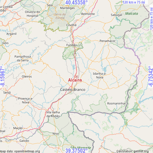
Alcains GPS coordinates[2]
39° 54' 59.112" North, 7° 27' 23.58" West
| Map corner | latitude | longitude |
|---|---|---|
| Upper-left | 40.45358°, | -8.15967° |
| Center: | 39.91642°, | -7.45655° |
| Lower-right: | 39.37502°, | -6.75342° |
| Map W x H: | 119.9×119.9 km | = 74.5×74.5mi |
| max Lat: | 42.11337° ⇑47.4% North |
| Alcains: | 39.91642° |
| min Lat: | ⇓52.6% South 32.6448° |
| min Long | Alcains | max Long |
| -31.17847° | -7.45655° | -6.27308° |
| W 93.6%⇐ | ⇒6.4% E |
Elevation
Elevation of Alcains is 362 m = 1188 ft, and this is 185 m = 607 ft above average elevation for this country.
| Max E: |
1008 m = 3307 ft | 14.8% |
| Alcains | 362 m 1188 ft | |
| Avg. | 177 m = 581 ft | |
Min E: |
-128 m = -420 ft | 85.2% |
See also: Portugal elevation on elevation.city.
Geographical zone
Alcains is located in North temperate zone (between Tropic of Cancer and the Arctic Circle). Distance of this Northern Tropic circle is 1832.4 km =1138.6 mi to South.| Distance of | km | miles | from Alcains |
|---|---|---|---|
| North Pole | 5568.8 | 3460.3 | to North |
| Arctic Circle | 2962.9 | 1841.1 | to North |
| Tropic Cancer | 1832.4 | 1138.6 | to South |
| Equator | 4438.3 | 2757.8 | to South |


Nearby cities:
15 places around Alcains: (largest is in red/bold)
• Aldeia de Joanes
25.3 km =15.7 mi,  348°
348°
• Barco
31.4 km =19.5 mi,  335°
335°
• Barroca Grande
36.3 km =22.6 mi,  316°
316°
• Castelo Branco
10.9 km =6.8 mi,  195°
195°
• Covilhã
40.8 km =25.4 mi, 354°
• Fundão
25.2 km =15.7 mi, 351°
• Idanha-a-Nova
18.4 km =11.4 mi,  87°
87°
• Monsanto
32.2 km =20 mi,  64°
64°
• Oleiros
39 km =24.2 mi,  270°
270°
• Penamacor
37.2 km =23.1 mi,  40°
40°
• Proença-a-Nova
43.9 km =27.3 mi,  245°
245°
• São Jorge da Beira
38.4 km =23.9 mi, 317°
• Unhais-o-Velho
38.4 km =23.9 mi,  308°
308°
• Vales do Rio
32.6 km =20.3 mi, 346°
• Vila Velha de Ródão
34.5 km =21.4 mi,  213°
213°
Sources, notices
• [Note1] Compared only with cities in Portugal existing in our database
• [Src1] Map data: © OpenStreetMap contributors (CC-BY-SA)
• [Src2] Other city data from geonames.org with taken over terms of usage.
• [Src3] Geographical zone / Annual Mean Temperature by Robert A. Rohde @ Wikipedia
