Belmonte geodata
Belmonte (Castelo Branco) is a seat of a second-order administrative division; located in Portugal in Europe/Lisbon (GMT+1) time zone. In our database, there are 824 cities with bigger population. Compared to other cities in Portugal, 58.9% of cities are located further ↓South; 95.9% of cities are located further ←West and 95.2% of cities have lower elevation than Belmonte. Note1


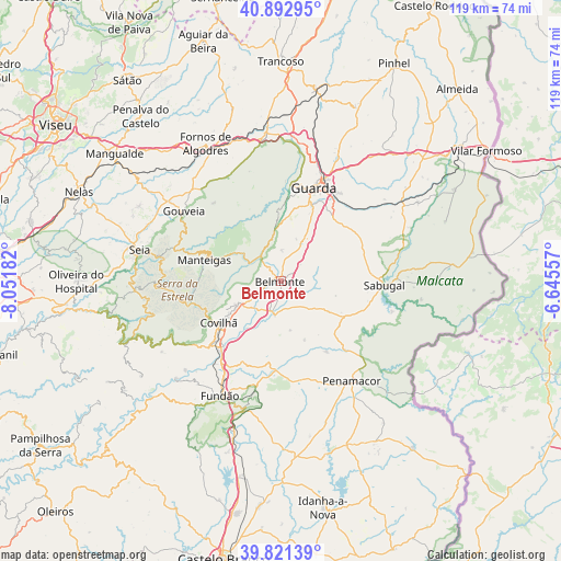
Belmonte GPS coordinates[2]
40° 21' 33.48" North, 7° 20' 55.284" West
| Map corner | latitude | longitude |
|---|---|---|
| Upper-left | 40.89295°, | -8.05182° |
| Center: | 40.3593°, | -7.34869° |
| Lower-right: | 39.82139°, | -6.64557° |
| Map W x H: | 119.1×119.1 km | = 74×74mi |
| max Lat: | 42.11337° ⇑41.1% North |
| Belmonte: | 40.3593° |
| min Lat: | ⇓58.9% South 32.6448° |
| min Long | Belmonte | max Long |
| -31.17847° | -7.34869° | -6.27308° |
| W 95.9%⇐ | ⇒4.1% E |
Elevation
Elevation of Belmonte is 606 m = 1988 ft, and this is 429 m = 1407 ft above average elevation for this country.
| Max E: |
1008 m = 3307 ft | 4.8% |
| Belmonte | 606 m 1988 ft | |
| Avg. | 177 m = 581 ft | |
Min E: |
-128 m = -420 ft | 95.2% |
See also: Portugal elevation on elevation.city.
Geographical zone
Belmonte is located in North temperate zone (between Tropic of Cancer and the Arctic Circle). Distance of this Northern Tropic circle is 1881.6 km =1169.2 mi to South.| Distance of | km | miles | from Belmonte |
|---|---|---|---|
| North Pole | 5519.5 | 3429.7 | to North |
| Arctic Circle | 2913.6 | 1810.4 | to North |
| Tropic Cancer | 1881.6 | 1169.2 | to South |
| Equator | 4487.5 | 2788.4 | to South |


Nearby cities:
15 places around Belmonte: (largest is in red/bold)
• Aldeia de Joanes
28.3 km =17.6 mi,  210°
210°
• Barco
30.1 km =18.7 mi,  226°
226°
• Celorico da Beira
31.1 km =19.3 mi,  353°
353°
• Covilhã
15.9 km =9.9 mi,  236°
236°
• Famalicão
9.6 km =6 mi, 345°
• Fundão
27.6 km =17.1 mi, 208°
• Guarda
21 km =13 mi,  19°
19°
• Loriga
29.1 km =18.1 mi,  262°
262°
• Manteigas
16.9 km =10.5 mi,  286°
286°
• Penamacor
26 km =16.2 mi,  144°
144°
• Sabugal
21.8 km =13.5 mi,  92°
92°
• Seia
31.1 km =19.3 mi,  281°
281°
• Sequeira
24 km =14.9 mi,  25°
25°
• Teixoso
10.5 km =6.5 mi, 241°
• Vales do Rio
24.2 km =15 mi,  223°
223°
Sources, notices
• [Note1] Compared only with cities in Portugal existing in our database
• [Src1] Map data: © OpenStreetMap contributors (CC-BY-SA)
• [Src2] Other city data from geonames.org with taken over terms of usage.
• [Src3] Geographical zone / Annual Mean Temperature by Robert A. Rohde @ Wikipedia
