Famalicão geodata
Famalicão (Guarda) is a populated place; located in Portugal in Europe/Lisbon (GMT+1) time zone. With population of 615 people, there are 808 cities with bigger population in this country. Compared to other cities in Portugal, 60.6% of cities are located further ↓South; 95.6% of cities are located further ←West and 96.4% of cities have lower elevation than Famalicão. Note1


Famalicão GPS coordinates[2]
40° 26' 35.448" North, 7° 22' 39.072" West
| Map corner | latitude | longitude |
|---|---|---|
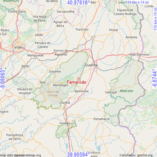
| Upper-left | 40.97616°, | -8.08065° |
| Center: | 40.44318°, | -7.37752° |
| Lower-right: | 39.90594°, | -6.6744° |
| Map W x H: | 119×119 km | = 73.9×73.9mi |
| max Lat: | 42.11337° ⇑39.4% North |
| Famalicão: | 40.44318° |
| min Lat: | ⇓60.6% South 32.6448° |
| min Long | Famalicão | max Long |
| -31.17847° | -7.37752° | -6.27308° |
| W 95.6%⇐ | ⇒4.4% E |
Elevation
Elevation of Famalicão is 657 m = 2156 ft, and this is 480 m = 1575 ft above average elevation for this country.
| Max E: |
1008 m = 3307 ft | 3.6% |
| Famalicão | 657 m 2156 ft | |
| Avg. | 177 m = 581 ft | |
Min E: |
-128 m = -420 ft | 96.4% |
See also: Portugal elevation on elevation.city.
Geographical zone
Famalicão is located in North temperate zone (between Tropic of Cancer and the Arctic Circle). Distance of this Northern Tropic circle is 1890.9 km =1175 mi to South.| Distance of | km | miles | from Famalicão |
|---|---|---|---|
| North Pole | 5510.2 | 3423.9 | to North |
| Arctic Circle | 2904.3 | 1804.6 | to North |
| Tropic Cancer | 1890.9 | 1175 | to South |
| Equator | 4496.9 | 2794.2 | to South |


Nearby cities:
15 places around Famalicão: (largest is in red/bold)
• Belmonte
9.6 km =6 mi,  165°
165°
• Celorico da Beira
21.6 km =13.4 mi,  357°
357°
• Covilhã
21 km =13 mi,  210°
210°
• Fornos de Algodres
24.8 km =15.4 mi,  326°
326°
• Guarda
14.1 km =8.8 mi,  42°
42°
• Loriga
29.5 km =18.3 mi,  243°
243°
• Manteigas
14.4 km =8.9 mi,  251°
251°
• Mesquitela
35 km =21.7 mi,  296°
296°
• Penamacor
35.2 km =21.9 mi,  149°
149°
• Sabugal
26.3 km =16.3 mi,  112°
112°
• Seia
28.2 km =17.5 mi,  263°
263°
• Sequeira
17.8 km =11.1 mi,  46°
46°
• São Romão
28.9 km =18 mi, 260°
• Teixoso
15.8 km =9.8 mi, 205°
• Vales do Rio
30.4 km =18.9 mi, 207°
Sources, notices
• [Note1] Compared only with cities in Portugal existing in our database
• [Src1] Map data: © OpenStreetMap contributors (CC-BY-SA)
• [Src2] Other city data from geonames.org with taken over terms of usage.
• [Src3] Geographical zone / Annual Mean Temperature by Robert A. Rohde @ Wikipedia
