Lordelo geodata
Lordelo (Braga) is a populated place; located in Portugal in Europe/Lisbon (GMT+1) time zone. With population of 4,560 people, there are 465 cities with bigger population in this country. Compared to other cities in Portugal, 86.3% of cities are located further ↓South; 64.4% of cities are located further ←West and 59.2% of cities have lower elevation than Lordelo. Note1


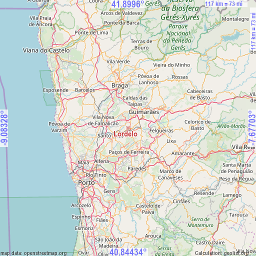
Lordelo GPS coordinates[2]
41° 22' 26.796" North, 8° 22' 48.576" West
| Map corner | latitude | longitude |
|---|---|---|
| Upper-left | 41.8996°, | -9.08328° |
| Center: | 41.37411°, | -8.38016° |
| Lower-right: | 40.84434°, | -7.67703° |
| Map W x H: | 117.3×117.3 km | = 72.9×72.9mi |
| max Lat: | 42.11337° ⇑13.7% North |
| Lordelo: | 41.37411° |
| min Lat: | ⇓86.3% South 32.6448° |
| min Long | Lordelo | max Long |
| -31.17847° | -8.38016° | -6.27308° |
| W 64.4%⇐ | ⇒35.6% E |
Elevation
Elevation of Lordelo is 150 m = 492 ft, and this is 27 m = 89 ft below average elevation for this country.
| Max E: |
1008 m = 3307 ft | 40.8% |
| Avg. | 177 m = 581 ft | |
| Lordelo | 150 m = 492 ft | |
Min E: |
-128 m = -420 ft | 59.2% |
See also: Portugal elevation on elevation.city.
Geographical zone
Lordelo is located in North temperate zone (between Tropic of Cancer and the Arctic Circle). Distance of this Northern Tropic circle is 1994.5 km =1239.3 mi to South.| Distance of | km | miles | from Lordelo |
|---|---|---|---|
| North Pole | 5406.7 | 3359.6 | to North |
| Arctic Circle | 2800.8 | 1740.3 | to North |
| Tropic Cancer | 1994.5 | 1239.3 | to South |
| Equator | 4600.4 | 2858.6 | to South |


Nearby cities:
15 places around Lordelo: (largest is in red/bold)
• Aves
2.5 km =1.6 mi,  260°
260°
• Barrosas
7.1 km =4.4 mi,  107°
107°
• Caldas de Vizela
6 km =3.7 mi,  81°
81°
• Candoso
7.7 km =4.8 mi,  39°
39°
• Carvalhosa
8.3 km =5.2 mi,  168°
168°
• Joane
7.6 km =4.7 mi,  341°
341°
• Lustosa
6.4 km =4 mi,  125°
125°
• Moreira de Conegos
3.7 km =2.3 mi,  67°
67°
• Negrelos
3.3 km =2.1 mi,  212°
212°
• Rebordões
4.2 km =2.6 mi,  239°
239°
• Riba de Ave
2.5 km =1.6 mi,  347°
347°
• Ronfe
7.5 km =4.7 mi,  357°
357°
• Selho
5.8 km =3.6 mi,  29°
29°
• Serzedelo
3.2 km =2 mi,  17°
17°
• Vilarinho
4.4 km =2.7 mi, 111°
Sources, notices
• [Note1] Compared only with cities in Portugal existing in our database
• [Src1] Map data: © OpenStreetMap contributors (CC-BY-SA)
• [Src2] Other city data from geonames.org with taken over terms of usage.
• [Src3] Geographical zone / Annual Mean Temperature by Robert A. Rohde @ Wikipedia
