Serzedelo geodata
Serzedelo (Braga) is a populated place; located in Portugal in Europe/Lisbon (GMT+1) time zone. With population of 4,020 people, there are 518 cities with bigger population in this country. Compared to other cities in Portugal, 87.7% of cities are located further ↓South; 65.2% of cities are located further ←West and 58.8% of cities have lower elevation than Serzedelo. Note1


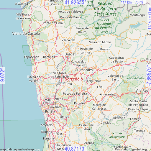
Serzedelo GPS coordinates[2]
41° 24' 4.608" North, 8° 22' 7.968" West
| Map corner | latitude | longitude |
|---|---|---|
| Upper-left | 41.92655°, | -9.072° |
| Center: | 41.40128°, | -8.36888° |
| Lower-right: | 40.87173°, | -7.66575° |
| Map W x H: | 117.3×117.3 km | = 72.9×72.9mi |
| max Lat: | 42.11337° ⇑12.3% North |
| Serzedelo: | 41.40128° |
| min Lat: | ⇓87.7% South 32.6448° |
| min Long | Serzedelo | max Long |
| -31.17847° | -8.36888° | -6.27308° |
| W 65.2%⇐ | ⇒34.8% E |
Elevation
Elevation of Serzedelo is 149 m = 489 ft, and this is 28 m = 92 ft below average elevation for this country.
| Max E: |
1008 m = 3307 ft | 41.2% |
| Avg. | 177 m = 581 ft | |
| Serzedelo | 149 m = 489 ft | |
Min E: |
-128 m = -420 ft | 58.8% |
See also: Portugal elevation on elevation.city.
Geographical zone
Serzedelo is located in North temperate zone (between Tropic of Cancer and the Arctic Circle). Distance of this Northern Tropic circle is 1997.5 km =1241.2 mi to South.| Distance of | km | miles | from Serzedelo |
|---|---|---|---|
| North Pole | 5403.7 | 3357.7 | to North |
| Arctic Circle | 2797.8 | 1738.5 | to North |
| Tropic Cancer | 1997.5 | 1241.2 | to South |
| Equator | 4603.4 | 2860.4 | to South |


Nearby cities:
15 places around Serzedelo: (largest is in red/bold)
• Aves
4.9 km =3 mi,  224°
224°
• Brito
6.4 km =4 mi,  5°
5°
• Caldas de Vizela
5.4 km =3.4 mi,  113°
113°
• Candoso
4.9 km =3 mi,  53°
53°
• Guimarães
7.7 km =4.8 mi, 51°
• Joane
5.3 km =3.3 mi,  321°
321°
• Lordelo
3.2 km =2 mi,  197°
197°
• Moreira de Conegos
2.9 km =1.8 mi,  123°
123°
• Negrelos
6.4 km =4 mi,  205°
205°
• Rebordões
6.9 km =4.3 mi, 221°
• Riba de Ave
1.6 km =1 mi,  250°
250°
• Ronfe
4.6 km =2.9 mi,  344°
344°
• Selho
2.8 km =1.7 mi,  43°
43°
• Urgeses
6.6 km =4.1 mi,  64°
64°
• Vilarinho
5.6 km =3.5 mi,  145°
145°
Sources, notices
• [Note1] Compared only with cities in Portugal existing in our database
• [Src1] Map data: © OpenStreetMap contributors (CC-BY-SA)
• [Src2] Other city data from geonames.org with taken over terms of usage.
• [Src3] Geographical zone / Annual Mean Temperature by Robert A. Rohde @ Wikipedia
