Lousã geodata
Lousã (Coimbra) is a populated place; located in Portugal in Europe/Lisbon (GMT+1) time zone. With population of 11,445 people, there are 184 cities with bigger population in this country. Compared to other cities in Portugal, 54.2% of cities are located further ↓South; 71.3% of cities are located further ←West and 59.2% of cities have lower elevation than Lousã. Note1


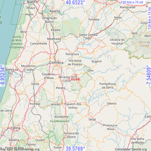
Lousã GPS coordinates[2]
40° 7' 0.228" North, 8° 14' 57.156" West
| Map corner | latitude | longitude |
|---|---|---|
| Upper-left | 40.6523°, | -8.95234° |
| Center: | 40.11673°, | -8.24921° |
| Lower-right: | 39.5769°, | -7.54609° |
| Map W x H: | 119.6×119.6 km | = 74.3×74.3mi |
| max Lat: | 42.11337° ⇑45.8% North |
| Lousã: | 40.11673° |
| min Lat: | ⇓54.2% South 32.6448° |
| min Long | Lousã | max Long |
| -31.17847° | -8.24921° | -6.27308° |
| W 71.3%⇐ | ⇒28.7% E |
Elevation
Elevation of Lousã is 150 m = 492 ft, and this is 27 m = 89 ft below average elevation for this country.
| Max E: |
1008 m = 3307 ft | 40.8% |
| Avg. | 177 m = 581 ft | |
| Lousã | 150 m = 492 ft | |
Min E: |
-128 m = -420 ft | 59.2% |
See also: Portugal elevation on elevation.city.
Geographical zone
Lousã is located in North temperate zone (between Tropic of Cancer and the Arctic Circle). Distance of this Northern Tropic circle is 1854.6 km =1152.4 mi to South.| Distance of | km | miles | from Lousã |
|---|---|---|---|
| North Pole | 5546.5 | 3446.4 | to North |
| Arctic Circle | 2940.6 | 1827.2 | to North |
| Tropic Cancer | 1854.6 | 1152.4 | to South |
| Equator | 4460.6 | 2771.7 | to South |


Nearby cities:
15 places around Lousã: (largest is in red/bold)
• Arganil
20.1 km =12.5 mi,  55°
55°
• Assafarge
16.2 km =10.1 mi,  286°
286°
• Castanheira de Pêra
12.6 km =7.8 mi,  164°
164°
• Coimbra
17.5 km =10.9 mi,  304°
304°
• Condeixa-a-Nova
21.2 km =13.2 mi,  268°
268°
• Friumes
17.5 km =10.9 mi,  9°
9°
• Góis
12.7 km =7.9 mi,  69°
69°
• Lorvão
16.9 km =10.5 mi,  340°
340°
• Miranda do Corvo
7.6 km =4.7 mi,  249°
249°
• Penacova
17.1 km =10.6 mi,  350°
350°
• Penela
14.7 km =9.1 mi,  230°
230°
• Poiares
10.4 km =6.5 mi,  356°
356°
• Santa Clara
18.7 km =11.6 mi, 299°
• Santo António dos Olivais
17.4 km =10.8 mi,  310°
310°
• Vila Nova de Ceira
11 km =6.8 mi,  49°
49°
Sources, notices
• [Note1] Compared only with cities in Portugal existing in our database
• [Src1] Map data: © OpenStreetMap contributors (CC-BY-SA)
• [Src2] Other city data from geonames.org with taken over terms of usage.
• [Src3] Geographical zone / Annual Mean Temperature by Robert A. Rohde @ Wikipedia
