Coimbra geodata
Coimbra is a seat of a first-order administrative division; located in Portugal in Europe/Lisbon (GMT+1) time zone. With population of 106,582 people, there are 5 cities with bigger population in this country. Compared to other cities in Portugal, 56.3% of cities are located further ↓South; 61.2% of cities are located further ←West and 53.6% of cities have higher elevation than Coimbra. Note1


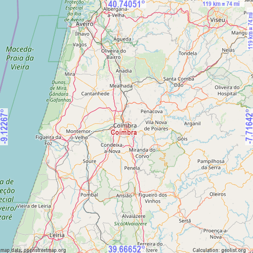
Coimbra GPS coordinates[2]
40° 12' 20.304" North, 8° 25' 10.38" West
| Map corner | latitude | longitude |
|---|---|---|
| Upper-left | 40.74051°, | -9.12267° |
| Center: | 40.20564°, | -8.41955° |
| Lower-right: | 39.66652°, | -7.71642° |
| Map W x H: | 119.4×119.4 km | = 74.2×74.2mi |
| max Lat: | 42.11337° ⇑43.7% North |
| Coimbra: | 40.20564° |
| min Lat: | ⇓56.3% South 32.6448° |
| min Long | Coimbra | max Long |
| -31.17847° | -8.41955° | -6.27308° |
| W 61.2%⇐ | ⇒38.8% E |
Elevation
Elevation of Coimbra is 98 m = 322 ft, and this is 79 m = 259 ft below average elevation for this country.
| Max E: |
1008 m = 3307 ft | 53.6% |
| Avg. | 177 m = 581 ft | |
| Coimbra | 98 m = 322 ft | |
Min E: |
-128 m = -420 ft | 46.4% |
See also: Coimbra elevation on elevation.city.
Geographical zone
Coimbra is located in North temperate zone (between Tropic of Cancer and the Arctic Circle). Distance of this Northern Tropic circle is 1864.5 km =1158.5 mi to South.| Distance of | km | miles | from Coimbra |
|---|---|---|---|
| North Pole | 5536.6 | 3440.3 | to North |
| Arctic Circle | 2930.7 | 1821.1 | to North |
| Tropic Cancer | 1864.5 | 1158.5 | to South |
| Equator | 4470.4 | 2777.8 | to South |


Nearby cities:
15 places around Coimbra: (largest is in red/bold)
• Ançã
11.3 km =7 mi,  310°
310°
• Assafarge
5.3 km =3.3 mi,  191°
191°
• Carapinheira
19.4 km =12.1 mi,  270°
270°
• Condeixa-a-Nova
12.3 km =7.6 mi,  212°
212°
• Friumes
18.8 km =11.7 mi,  66°
66°
• Lorvão
10.6 km =6.6 mi,  55°
55°
• Lousã
17.5 km =10.9 mi,  124°
124°
• Mealhada
19.3 km =12 mi,  352°
352°
• Miranda do Corvo
14.5 km =9 mi,  149°
149°
• Pampilhosa do Botão
14.5 km =9 mi,  357°
357°
• Penacova
13.6 km =8.5 mi, 58°
• Penela
19.4 km =12.1 mi,  170°
170°
• Poiares
13.8 km =8.6 mi,  87°
87°
• Santa Clara
1.9 km =1.2 mi,  249°
249°
• Santo António dos Olivais
1.8 km =1.1 mi,  41°
41°
Sources, notices
• [Note1] Compared only with cities in Portugal existing in our database
• [Src1] Map data: © OpenStreetMap contributors (CC-BY-SA)
• [Src2] Other city data from geonames.org with taken over terms of usage.
• [Src3] Geographical zone / Annual Mean Temperature by Robert A. Rohde @ Wikipedia
