Lorvão geodata
Lorvão (Coimbra) is a populated place; located in Portugal in Europe/Lisbon (GMT+1) time zone. With population of 4,158 people, there are 504 cities with bigger population in this country. Compared to other cities in Portugal, 56.9% of cities are located further ↓South; 68% of cities are located further ←West and 64.1% of cities have lower elevation than Lorvão. Note1


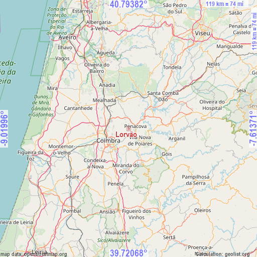
Lorvão GPS coordinates[2]
40° 15' 33.768" North, 8° 19' 0.588" West
| Map corner | latitude | longitude |
|---|---|---|
| Upper-left | 40.79382°, | -9.01996° |
| Center: | 40.25938°, | -8.31683° |
| Lower-right: | 39.72068°, | -7.61371° |
| Map W x H: | 119.3×119.3 km | = 74.1×74.1mi |
| max Lat: | 42.11337° ⇑43.1% North |
| Lorvão: | 40.25938° |
| min Lat: | ⇓56.9% South 32.6448° |
| min Long | Lorvão | max Long |
| -31.17847° | -8.31683° | -6.27308° |
| W 68%⇐ | ⇒32% E |
Elevation
Elevation of Lorvão is 174 m = 571 ft, and this is 3 m = 10 ft below average elevation for this country.
| Max E: |
1008 m = 3307 ft | 35.9% |
| Avg. | 177 m = 581 ft | |
| Lorvão | 174 m = 571 ft | |
Min E: |
-128 m = -420 ft | 64.1% |
See also: Portugal elevation on elevation.city.
Geographical zone
Lorvão is located in North temperate zone (between Tropic of Cancer and the Arctic Circle). Distance of this Northern Tropic circle is 1870.5 km =1162.3 mi to South.| Distance of | km | miles | from Lorvão |
|---|---|---|---|
| North Pole | 5530.6 | 3436.6 | to North |
| Arctic Circle | 2924.8 | 1817.4 | to North |
| Tropic Cancer | 1870.5 | 1162.3 | to South |
| Equator | 4476.4 | 2781.5 | to South |


Nearby cities:
15 places around Lorvão: (largest is in red/bold)
• Assafarge
14.8 km =9.2 mi,  221°
221°
• Coimbra
10.6 km =6.6 mi,  235°
235°
• Friumes
8.7 km =5.4 mi,  80°
80°
• Lousã
16.9 km =10.5 mi,  160°
160°
• Luso
14.8 km =9.2 mi,  339°
339°
• Mortágua
16.9 km =10.5 mi,  25°
25°
• Oliveira do Mondego
10.6 km =6.6 mi,  48°
48°
• Pampilhosa do Botão
12.7 km =7.9 mi,  312°
312°
• Penacova
3.1 km =1.9 mi,  70°
70°
• Poiares
7.4 km =4.6 mi,  137°
137°
• Santa Clara
12.4 km =7.7 mi, 237°
• Santo António dos Olivais
8.8 km =5.5 mi, 238°
• São Pedro de Alva
13.6 km =8.5 mi, 70°
• Travanca
13.1 km =8.1 mi,  57°
57°
• Vila Nova de Ceira
16.5 km =10.3 mi,  121°
121°
Sources, notices
• [Note1] Compared only with cities in Portugal existing in our database
• [Src1] Map data: © OpenStreetMap contributors (CC-BY-SA)
• [Src2] Other city data from geonames.org with taken over terms of usage.
• [Src3] Geographical zone / Annual Mean Temperature by Robert A. Rohde @ Wikipedia
