Condeixa-a-Nova geodata
Condeixa-a-Nova (Coimbra) is a seat of a second-order administrative division; located in Portugal in Europe/Lisbon (GMT+1) time zone. With population of 17,078 people, there are 123 cities with bigger population in this country. Compared to other cities in Portugal, 54.1% of cities are located further ↓South; 54.6% of cities are located further ←West and 51.1% of cities have higher elevation than Condeixa-a-Nova. Note1


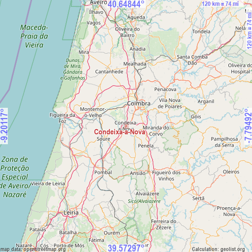
Condeixa-a-Nova GPS coordinates[2]
40° 6' 46.188" North, 8° 29' 52.944" West
| Map corner | latitude | longitude |
|---|---|---|
| Upper-left | 40.64844°, | -9.20117° |
| Center: | 40.11283°, | -8.49804° |
| Lower-right: | 39.57297°, | -7.79492° |
| Map W x H: | 119.6×119.6 km | = 74.3×74.3mi |
| max Lat: | 42.11337° ⇑45.9% North |
| Condeixa-a-Nova: | 40.11283° |
| min Lat: | ⇓54.1% South 32.6448° |
| min Long | Condeixa-a-Nova | max Long |
| -31.17847° | -8.49804° | -6.27308° |
| W 54.6%⇐ | ⇒45.4% E |
Elevation
Elevation of Condeixa-a-Nova is 109 m = 358 ft, and this is 68 m = 223 ft below average elevation for this country.
| Max E: |
1008 m = 3307 ft | 51.1% |
| Avg. | 177 m = 581 ft | |
| Condeixa-a-Nova | 109 m = 358 ft | |
Min E: |
-128 m = -420 ft | 48.9% |
See also: Portugal elevation on elevation.city.
Geographical zone
Condeixa-a-Nova is located in North temperate zone (between Tropic of Cancer and the Arctic Circle). Distance of this Northern Tropic circle is 1854.2 km =1152.1 mi to South.| Distance of | km | miles | from Condeixa-a-Nova |
|---|---|---|---|
| North Pole | 5546.9 | 3446.7 | to North |
| Arctic Circle | 2941 | 1827.5 | to North |
| Tropic Cancer | 1854.2 | 1152.1 | to South |
| Equator | 4460.1 | 2771.4 | to South |


Nearby cities:
15 places around Condeixa-a-Nova: (largest is in red/bold)
• Alfarelos
13.8 km =8.6 mi,  287°
287°
• Ansião
23 km =14.3 mi,  166°
166°
• Ançã
17.8 km =11.1 mi,  353°
353°
• Assafarge
7.6 km =4.7 mi,  47°
47°
• Carapinheira
16.4 km =10.2 mi,  309°
309°
• Coimbra
12.3 km =7.6 mi,  32°
32°
• Lorvão
22.4 km =13.9 mi,  43°
43°
• Lousã
21.2 km =13.2 mi,  88°
88°
• Miranda do Corvo
14.2 km =8.8 mi,  98°
98°
• Montemor-o-Velho
17.3 km =10.7 mi, 292°
• Penela
13.2 km =8.2 mi,  132°
132°
• Poiares
23.1 km =14.4 mi,  62°
62°
• Santa Clara
10.9 km =6.8 mi, 26°
• Santo António dos Olivais
14.1 km =8.8 mi, 33°
• Soure
12.4 km =7.7 mi,  241°
241°
Sources, notices
• [Note1] Compared only with cities in Portugal existing in our database
• [Src1] Map data: © OpenStreetMap contributors (CC-BY-SA)
• [Src2] Other city data from geonames.org with taken over terms of usage.
• [Src3] Geographical zone / Annual Mean Temperature by Robert A. Rohde @ Wikipedia
