Santa Clara geodata
Santa Clara (Coimbra) is a populated place; located in Portugal in Europe/Lisbon (GMT+1) time zone. With population of 9,637 people, there are 224 cities with bigger population in this country. Compared to other cities in Portugal, 56.1% of cities are located further ↓South; 59.4% of cities are located further ←West and 91.6% of cities have higher elevation than Santa Clara. Note1


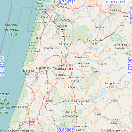
Santa Clara GPS coordinates[2]
40° 11' 59.46" North, 8° 26' 24.648" West
| Map corner | latitude | longitude |
|---|---|---|
| Upper-left | 40.73477°, | -9.14331° |
| Center: | 40.19985°, | -8.44018° |
| Lower-right: | 39.66068°, | -7.73706° |
| Map W x H: | 119.4×119.4 km | = 74.2×74.2mi |
| max Lat: | 42.11337° ⇑43.9% North |
| Santa Clara: | 40.19985° |
| min Lat: | ⇓56.1% South 32.6448° |
| min Long | Santa Clara | max Long |
| -31.17847° | -8.44018° | -6.27308° |
| W 59.4%⇐ | ⇒40.6% E |
Elevation
Elevation of Santa Clara is 14 m = 46 ft, and this is 163 m = 535 ft below average elevation for this country.
| Max E: |
1008 m = 3307 ft | 91.6% |
| Avg. | 177 m = 581 ft | |
| Santa Clara | 14 m = 46 ft | |
Min E: |
-128 m = -420 ft | 8.4% |
See also: Portugal elevation on elevation.city.
Geographical zone
Santa Clara is located in North temperate zone (between Tropic of Cancer and the Arctic Circle). Distance of this Northern Tropic circle is 1863.9 km =1158.2 mi to South.| Distance of | km | miles | from Santa Clara |
|---|---|---|---|
| North Pole | 5537.3 | 3440.7 | to North |
| Arctic Circle | 2931.4 | 1821.5 | to North |
| Tropic Cancer | 1863.9 | 1158.2 | to South |
| Equator | 4469.8 | 2777.4 | to South |


Nearby cities:
15 places around Santa Clara: (largest is in red/bold)
• Alfarelos
18.9 km =11.7 mi,  253°
253°
• Ançã
10.5 km =6.5 mi,  319°
319°
• Assafarge
4.6 km =2.9 mi,  170°
170°
• Carapinheira
17.7 km =11 mi,  272°
272°
• Coimbra
1.9 km =1.2 mi,  69°
69°
• Condeixa-a-Nova
10.9 km =6.8 mi,  206°
206°
• Lorvão
12.4 km =7.7 mi,  57°
57°
• Lousã
18.7 km =11.6 mi,  119°
119°
• Mealhada
19.8 km =12.3 mi,  357°
357°
• Miranda do Corvo
15 km =9.3 mi,  142°
142°
• Pampilhosa do Botão
15.2 km =9.4 mi,  4°
4°
• Penacova
15.4 km =9.6 mi, 60°
• Penela
19.1 km =11.9 mi, 165°
• Poiares
15.6 km =9.7 mi,  85°
85°
• Santo António dos Olivais
3.6 km =2.2 mi, 55°
Sources, notices
• [Note1] Compared only with cities in Portugal existing in our database
• [Src1] Map data: © OpenStreetMap contributors (CC-BY-SA)
• [Src2] Other city data from geonames.org with taken over terms of usage.
• [Src3] Geographical zone / Annual Mean Temperature by Robert A. Rohde @ Wikipedia
