Poiares geodata
Poiares (Coimbra) is a seat of a second-order administrative division; located in Portugal in Europe/Lisbon (GMT+1) time zone. With population of 5,514 people, there are 392 cities with bigger population in this country. Compared to other cities in Portugal, 56.6% of cities are located further ↓South; 70.8% of cities are located further ←West and 56.9% of cities have lower elevation than Poiares. Note1
Administrative division(s):
- Level 1: Coimbra
- Level 2: Vila Nova de Poiares
- Level 3: Poiares (Santo André)


Poiares GPS coordinates[2]
40° 12' 36.936" North, 8° 15' 26.856" West
| Map corner | latitude | longitude |
|---|---|---|
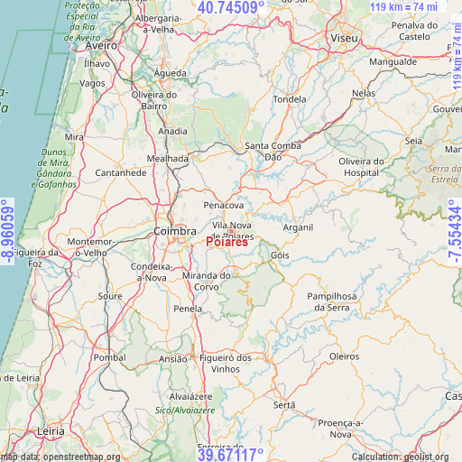
| Upper-left | 40.74509°, | -8.96059° |
| Center: | 40.21026°, | -8.25746° |
| Lower-right: | 39.67117°, | -7.55434° |
| Map W x H: | 119.4×119.4 km | = 74.2×74.2mi |
| max Lat: | 42.11337° ⇑43.4% North |
| Poiares: | 40.21026° |
| min Lat: | ⇓56.6% South 32.6448° |
| min Long | Poiares | max Long |
| -31.17847° | -8.25746° | -6.27308° |
| W 70.8%⇐ | ⇒29.2% E |
Elevation
Elevation of Poiares is 136 m = 446 ft, and this is 41 m = 135 ft below average elevation for this country.
| Max E: |
1008 m = 3307 ft | 43.1% |
| Avg. | 177 m = 581 ft | |
| Poiares | 136 m = 446 ft | |
Min E: |
-128 m = -420 ft | 56.9% |
See also: Portugal elevation on elevation.city.
Geographical zone
Poiares is located in North temperate zone (between Tropic of Cancer and the Arctic Circle). Distance of this Northern Tropic circle is 1865 km =1158.9 mi to South.| Distance of | km | miles | from Poiares |
|---|---|---|---|
| North Pole | 5536.1 | 3440 | to North |
| Arctic Circle | 2930.2 | 1820.7 | to North |
| Tropic Cancer | 1865 | 1158.9 | to South |
| Equator | 4471 | 2778.1 | to South |


Nearby cities:
15 places around Poiares: (largest is in red/bold)
• Arganil
17.3 km =10.7 mi,  87°
87°
• Assafarge
15.9 km =9.9 mi,  248°
248°
• Coimbra
13.8 km =8.6 mi,  267°
267°
• Friumes
7.8 km =4.8 mi,  27°
27°
• Góis
13.8 km =8.6 mi,  115°
115°
• Lorvão
7.4 km =4.6 mi,  317°
317°
• Lousã
10.4 km =6.5 mi,  176°
176°
• Miranda do Corvo
14.5 km =9 mi,  206°
206°
• Oliveira do Mondego
12.9 km =8 mi,  12°
12°
• Penacova
6.8 km =4.2 mi,  342°
342°
• Santa Clara
15.6 km =9.7 mi, 265°
• Santo António dos Olivais
12.6 km =7.8 mi, 273°
• São Pedro de Alva
12.7 km =7.9 mi,  37°
37°
• Travanca
13.9 km =8.6 mi, 25°
• Vila Nova de Ceira
9.6 km =6 mi,  109°
109°
Sources, notices
• [Note1] Compared only with cities in Portugal existing in our database
• [Src1] Map data: © OpenStreetMap contributors (CC-BY-SA)
• [Src2] Other city data from geonames.org with taken over terms of usage.
• [Src3] Geographical zone / Annual Mean Temperature by Robert A. Rohde @ Wikipedia
