Penacova geodata
Penacova (Coimbra) is a seat of a second-order administrative division; located in Portugal in Europe/Lisbon (GMT+1) time zone. With population of 3,254 people, there are 574 cities with bigger population in this country. Compared to other cities in Portugal, 57% of cities are located further ↓South; 69.8% of cities are located further ←West and 58% of cities have lower elevation than Penacova. Note1


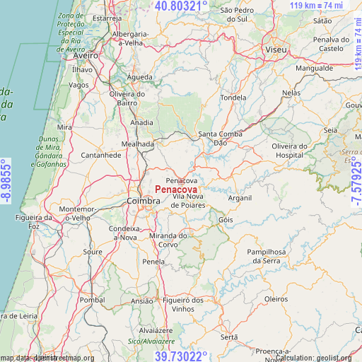
Penacova GPS coordinates[2]
40° 16' 7.824" North, 8° 16' 56.532" West
| Map corner | latitude | longitude |
|---|---|---|
| Upper-left | 40.80321°, | -8.9855° |
| Center: | 40.26884°, | -8.28237° |
| Lower-right: | 39.73022°, | -7.57925° |
| Map W x H: | 119.3×119.3 km | = 74.1×74.1mi |
| max Lat: | 42.11337° ⇑43% North |
| Penacova: | 40.26884° |
| min Lat: | ⇓57% South 32.6448° |
| min Long | Penacova | max Long |
| -31.17847° | -8.28237° | -6.27308° |
| W 69.8%⇐ | ⇒30.2% E |
Elevation
Elevation of Penacova is 143 m = 469 ft, and this is 34 m = 112 ft below average elevation for this country.
| Max E: |
1008 m = 3307 ft | 42% |
| Avg. | 177 m = 581 ft | |
| Penacova | 143 m = 469 ft | |
Min E: |
-128 m = -420 ft | 58% |
See also: Portugal elevation on elevation.city.
Geographical zone
Penacova is located in North temperate zone (between Tropic of Cancer and the Arctic Circle). Distance of this Northern Tropic circle is 1871.6 km =1163 mi to South.| Distance of | km | miles | from Penacova |
|---|---|---|---|
| North Pole | 5529.6 | 3435.9 | to North |
| Arctic Circle | 2923.7 | 1816.7 | to North |
| Tropic Cancer | 1871.6 | 1163 | to South |
| Equator | 4477.5 | 2782.2 | to South |


Nearby cities:
15 places around Penacova: (largest is in red/bold)
• Assafarge
17.6 km =10.9 mi,  226°
226°
• Coimbra
13.6 km =8.5 mi,  238°
238°
• Friumes
5.7 km =3.5 mi,  86°
86°
• Lorvão
3.1 km =1.9 mi,  250°
250°
• Lousã
17.1 km =10.6 mi,  170°
170°
• Luso
15.2 km =9.4 mi,  327°
327°
• Mortágua
14.8 km =9.2 mi,  16°
16°
• Oliveira do Mondego
7.8 km =4.8 mi,  39°
39°
• Pampilhosa do Botão
14.4 km =8.9 mi,  301°
301°
• Poiares
6.8 km =4.2 mi,  162°
162°
• Santa Clara
15.4 km =9.6 mi, 240°
• Santo António dos Olivais
11.9 km =7.4 mi, 241°
• São Pedro de Alva
10.5 km =6.5 mi,  70°
70°
• Travanca
10.1 km =6.3 mi,  53°
53°
• Vila Nova de Ceira
14.7 km =9.1 mi,  131°
131°
Sources, notices
• [Note1] Compared only with cities in Portugal existing in our database
• [Src1] Map data: © OpenStreetMap contributors (CC-BY-SA)
• [Src2] Other city data from geonames.org with taken over terms of usage.
• [Src3] Geographical zone / Annual Mean Temperature by Robert A. Rohde @ Wikipedia
