Caldas das Taipas geodata
Caldas das Taipas (Braga) is a populated place; located in Portugal in Europe/Lisbon (GMT+1) time zone. With population of 5,723 people, there are 379 cities with bigger population in this country. Compared to other cities in Portugal, 91.5% of cities are located further ↓South; 66.2% of cities are located further ←West and 55.7% of cities have lower elevation than Caldas das Taipas. Note1


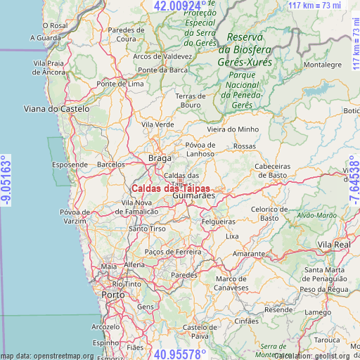
Caldas das Taipas GPS coordinates[2]
41° 29' 4.74" North, 8° 20' 54.6" West
| Map corner | latitude | longitude |
|---|---|---|
| Upper-left | 42.00924°, | -9.05163° |
| Center: | 41.48465°, | -8.3485° |
| Lower-right: | 40.95578°, | -7.64538° |
| Map W x H: | 117.1×117.1 km | = 72.8×72.8mi |
| max Lat: | 42.11337° ⇑8.5% North |
| Caldas das Taipas: | 41.48465° |
| min Lat: | ⇓91.5% South 32.6448° |
| min Long | Caldas das Taip | max Long |
| -31.17847° | -8.3485° | -6.27308° |
| W 66.2%⇐ | ⇒33.8% E |
Elevation
Elevation of Caldas das Taipas is 131 m = 430 ft, and this is 46 m = 151 ft below average elevation for this country.
| Max E: |
1008 m = 3307 ft | 44.3% |
| Avg. | 177 m = 581 ft | |
| Caldas das Taipas | 131 m = 430 ft | |
Min E: |
-128 m = -420 ft | 55.7% |
See also: Portugal elevation on elevation.city.
Geographical zone
Caldas das Taipas is located in North temperate zone (between Tropic of Cancer and the Arctic Circle). Distance of this Northern Tropic circle is 2006.7 km =1246.9 mi to South.| Distance of | km | miles | from Caldas das Taipas |
|---|---|---|---|
| North Pole | 5394.4 | 3351.9 | to North |
| Arctic Circle | 2788.5 | 1732.7 | to North |
| Tropic Cancer | 2006.7 | 1246.9 | to South |
| Equator | 4612.7 | 2866.2 | to South |


Nearby cities:
15 places around Caldas das Taipas: (largest is in red/bold)
• Arcos
7.4 km =4.6 mi,  304°
304°
• Braga
9.4 km =5.8 mi,  320°
320°
• Brito
3.1 km =1.9 mi,  199°
199°
• Candoso
6.7 km =4.2 mi,  160°
160°
• Esporões
6.4 km =4 mi, 296°
• Guimarães
6.2 km =3.9 mi,  135°
135°
• Guisande
8.1 km =5 mi,  268°
268°
• Joane
7.1 km =4.4 mi,  224°
224°
• Lamas
7.4 km =4.6 mi,  285°
285°
• Oliveira
10.1 km =6.3 mi, 265°
• Ponte
2.2 km =1.4 mi, 135°
• Ronfe
5.6 km =3.5 mi,  211°
211°
• Selho
7.3 km =4.5 mi,  178°
178°
• Serzedelo
9.4 km =5.8 mi,  190°
190°
• Urgeses
7.7 km =4.8 mi,  146°
146°
Sources, notices
• [Note1] Compared only with cities in Portugal existing in our database
• [Src1] Map data: © OpenStreetMap contributors (CC-BY-SA)
• [Src2] Other city data from geonames.org with taken over terms of usage.
• [Src3] Geographical zone / Annual Mean Temperature by Robert A. Rohde @ Wikipedia
