Ponte geodata
Ponte (Braga) is a populated place; located in Portugal in Europe/Lisbon (GMT+1) time zone. With population of 7,041 people, there are 320 cities with bigger population in this country. Compared to other cities in Portugal, 90.7% of cities are located further ↓South; 67.6% of cities are located further ←West and 56% of cities have lower elevation than Ponte. Note1


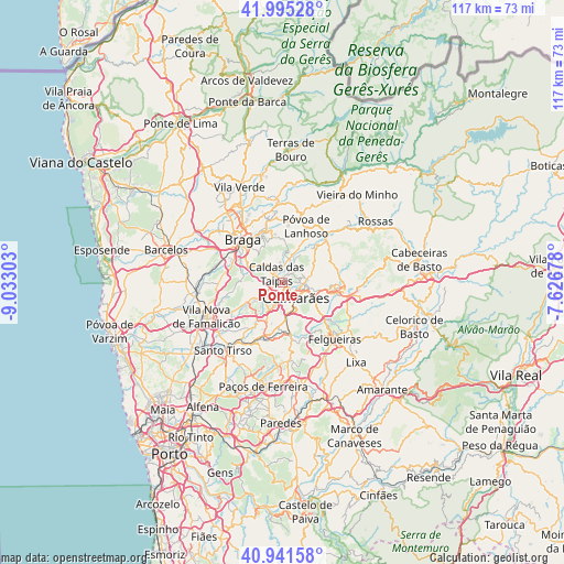
Ponte GPS coordinates[2]
41° 28' 14.052" North, 8° 19' 47.64" West
| Map corner | latitude | longitude |
|---|---|---|
| Upper-left | 41.99528°, | -9.03303° |
| Center: | 41.47057°, | -8.3299° |
| Lower-right: | 40.94158°, | -7.62678° |
| Map W x H: | 117.2×117.2 km | = 72.8×72.8mi |
| max Lat: | 42.11337° ⇑9.3% North |
| Ponte: | 41.47057° |
| min Lat: | ⇓90.7% South 32.6448° |
| min Long | Ponte | max Long |
| -31.17847° | -8.3299° | -6.27308° |
| W 67.6%⇐ | ⇒32.4% E |
Elevation
Elevation of Ponte is 133 m = 436 ft, and this is 44 m = 144 ft below average elevation for this country.
| Max E: |
1008 m = 3307 ft | 44% |
| Avg. | 177 m = 581 ft | |
| Ponte | 133 m = 436 ft | |
Min E: |
-128 m = -420 ft | 56% |
See also: Portugal elevation on elevation.city.
Geographical zone
Ponte is located in North temperate zone (between Tropic of Cancer and the Arctic Circle). Distance of this Northern Tropic circle is 2005.2 km =1246 mi to South.| Distance of | km | miles | from Ponte |
|---|---|---|---|
| North Pole | 5396 | 3352.9 | to North |
| Arctic Circle | 2790.1 | 1733.7 | to North |
| Tropic Cancer | 2005.2 | 1246 | to South |
| Equator | 4611.1 | 2865.2 | to South |


Nearby cities:
15 places around Ponte: (largest is in red/bold)
• Arcos
9.5 km =5.9 mi,  306°
306°
• Brito
2.9 km =1.8 mi,  242°
242°
• Caldas das Taipas
2.2 km =1.4 mi,  315°
315°
• Candoso
4.8 km =3 mi,  171°
171°
• Esporões
8.5 km =5.3 mi,  301°
301°
• Guimarães
4 km =2.5 mi,  135°
135°
• Guisande
9.7 km =6 mi,  277°
277°
• Joane
7.4 km =4.6 mi, 241°
• Lamas
9.4 km =5.8 mi,  292°
292°
• Moreira de Conegos
9.3 km =5.8 mi,  184°
184°
• Riba de Ave
9.5 km =5.9 mi,  209°
209°
• Ronfe
5.6 km =3.5 mi,  234°
234°
• Selho
5.8 km =3.6 mi,  193°
193°
• Serzedelo
8.4 km =5.2 mi,  202°
202°
• Urgeses
5.5 km =3.4 mi,  151°
151°
Sources, notices
• [Note1] Compared only with cities in Portugal existing in our database
• [Src1] Map data: © OpenStreetMap contributors (CC-BY-SA)
• [Src2] Other city data from geonames.org with taken over terms of usage.
• [Src3] Geographical zone / Annual Mean Temperature by Robert A. Rohde @ Wikipedia
