Lavra geodata
Lavra (Porto) is a populated place; located in Portugal in Europe/Lisbon (GMT+1) time zone. With population of 9,633 people, there are 225 cities with bigger population in this country. Compared to other cities in Portugal, 81.8% of cities are located further ↓South; 63.9% of cities are located further →East and 91.2% of cities have higher elevation than Lavra. Note1


Lavra GPS coordinates[2]
41° 15' 33.66" North, 8° 43' 6.564" West
| Map corner | latitude | longitude |
|---|---|---|
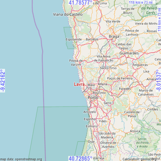
| Upper-left | 41.78577°, | -9.42162° |
| Center: | 41.25935°, | -8.71849° |
| Lower-right: | 40.72865°, | -8.01537° |
| Map W x H: | 117.5×117.5 km | = 73×73mi |
| max Lat: | 42.11337° ⇑18.2% North |
| Lavra: | 41.25935° |
| min Lat: | ⇓81.8% South 32.6448° |
| min Long | Lavra | max Long |
| -31.17847° | -8.71849° | -6.27308° |
| W 36.1%⇐ | ⇒63.9% E |
Elevation
Elevation of Lavra is 15 m = 49 ft, and this is 162 m = 531 ft below average elevation for this country.
| Max E: |
1008 m = 3307 ft | 91.2% |
| Avg. | 177 m = 581 ft | |
| Lavra | 15 m = 49 ft | |
Min E: |
-128 m = -420 ft | 8.8% |
See also: Portugal elevation on elevation.city.
Geographical zone
Lavra is located in North temperate zone (between Tropic of Cancer and the Arctic Circle). Distance of this Northern Tropic circle is 1981.7 km =1231.4 mi to South.| Distance of | km | miles | from Lavra |
|---|---|---|---|
| North Pole | 5419.5 | 3367.5 | to North |
| Arctic Circle | 2813.6 | 1748.3 | to North |
| Tropic Cancer | 1981.7 | 1231.4 | to South |
| Equator | 4587.6 | 2850.6 | to South |


Nearby cities:
15 places around Lavra: (largest is in red/bold)
• Anta
7.6 km =4.7 mi,  84°
84°
• Gemunde
6.2 km =3.9 mi, 81°
• Guifões
8 km =5 mi,  148°
148°
• Leça da Palmeira
7.8 km =4.8 mi,  168°
168°
• Leça do Bailio
8.8 km =5.5 mi,  126°
126°
• Maia
8.7 km =5.4 mi,  107°
107°
• Matosinhos
8.9 km =5.5 mi,  164°
164°
• Mindelo
6.2 km =3.9 mi,  357°
357°
• Moreira
6 km =3.7 mi,  102°
102°
• Nogueira
11.2 km =7 mi, 99°
• Santa Cruz do Bispo
6.2 km =3.9 mi,  143°
143°
• Senhora da Hora
9.8 km =6.1 mi, 145°
• Vairão
9.3 km =5.8 mi,  27°
27°
• Vila do Conde
10.7 km =6.6 mi,  347°
347°
• Árvore
8.9 km =5.5 mi,  0°
0°
Sources, notices
• [Note1] Compared only with cities in Portugal existing in our database
• [Src1] Map data: © OpenStreetMap contributors (CC-BY-SA)
• [Src2] Other city data from geonames.org with taken over terms of usage.
• [Src3] Geographical zone / Annual Mean Temperature by Robert A. Rohde @ Wikipedia
