Montemor-o-Velho geodata
Montemor-o-Velho (Coimbra) is a seat of a second-order administrative division; located in Portugal in Europe/Lisbon (GMT+1) time zone. With population of 3,154 people, there are 581 cities with bigger population in this country. Compared to other cities in Portugal, 55.7% of cities are located further ↓South; 62% of cities are located further →East and 87.7% of cities have higher elevation than Montemor-o-Velho. Note1


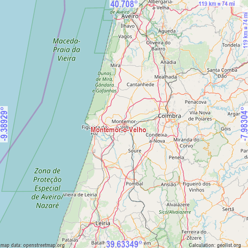
Montemor-o-Velho GPS coordinates[2]
40° 10' 22.332" North, 8° 41' 10.176" West
| Map corner | latitude | longitude |
|---|---|---|
| Upper-left | 40.708°, | -9.38929° |
| Center: | 40.17287°, | -8.68616° |
| Lower-right: | 39.63349°, | -7.98304° |
| Map W x H: | 119.5×119.5 km | = 74.3×74.3mi |
| max Lat: | 42.11337° ⇑44.3% North |
| Montemor-o-Velho: | 40.17287° |
| min Lat: | ⇓55.7% South 32.6448° |
| min Long | Montemor-o-Velh | max Long |
| -31.17847° | -8.68616° | -6.27308° |
| W 38%⇐ | ⇒62% E |
Elevation
Elevation of Montemor-o-Velho is 20 m = 66 ft, and this is 157 m = 515 ft below average elevation for this country.
| Max E: |
1008 m = 3307 ft | 87.7% |
| Avg. | 177 m = 581 ft | |
| Montemor-o-Velho | 20 m = 66 ft | |
Min E: |
-128 m = -420 ft | 12.3% |
See also: Portugal elevation on elevation.city.
Geographical zone
Montemor-o-Velho is located in North temperate zone (between Tropic of Cancer and the Arctic Circle). Distance of this Northern Tropic circle is 1860.9 km =1156.3 mi to South.| Distance of | km | miles | from Montemor-o-Velho |
|---|---|---|---|
| North Pole | 5540.3 | 3442.6 | to North |
| Arctic Circle | 2934.4 | 1823.4 | to North |
| Tropic Cancer | 1860.9 | 1156.3 | to South |
| Equator | 4466.8 | 2775.5 | to South |


Nearby cities:
15 places around Montemor-o-Velho: (largest is in red/bold)
• Alfarelos
3.7 km =2.3 mi,  131°
131°
• Alhadas
9 km =5.6 mi,  279°
279°
• Ançã
17.8 km =11.1 mi,  51°
51°
• Arazede
13 km =8.1 mi,  13°
13°
• Buarcos
16.2 km =10.1 mi,  267°
267°
• Cantanhede
20.8 km =12.9 mi,  21°
21°
• Carapinheira
4.9 km =3 mi,  41°
41°
• Condeixa-a-Nova
17.3 km =10.7 mi,  112°
112°
• Figueira da Foz
15.1 km =9.4 mi,  260°
260°
• Lavos
15 km =9.3 mi,  233°
233°
• Louriçal
19.3 km =12 mi,  193°
193°
• Santa Clara
21.1 km =13.1 mi,  81°
81°
• Soure
13.6 km =8.5 mi,  157°
157°
• Tavarede
13.6 km =8.5 mi, 267°
• Tocha
16.6 km =10.3 mi,  339°
339°
Sources, notices
• [Note1] Compared only with cities in Portugal existing in our database
• [Src1] Map data: © OpenStreetMap contributors (CC-BY-SA)
• [Src2] Other city data from geonames.org with taken over terms of usage.
• [Src3] Geographical zone / Annual Mean Temperature by Robert A. Rohde @ Wikipedia
