Alfarelos geodata
Alfarelos (Coimbra) is a populated place; located in Portugal in Europe/Lisbon (GMT+1) time zone. With population of 1,439 people, there are 696 cities with bigger population in this country. Compared to other cities in Portugal, 54.6% of cities are located further ↓South; 59.3% of cities are located further →East and 66% of cities have higher elevation than Alfarelos. Note1


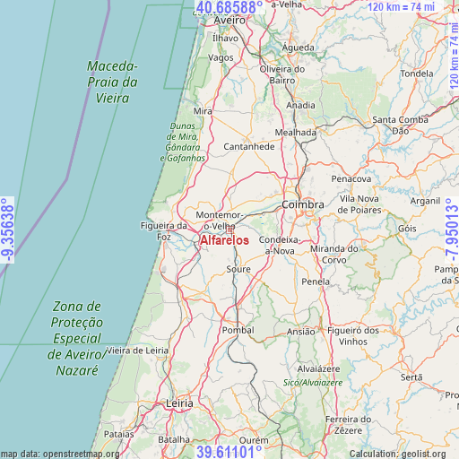
Alfarelos GPS coordinates[2]
40° 9' 2.052" North, 8° 39' 11.736" West
| Map corner | latitude | longitude |
|---|---|---|
| Upper-left | 40.68588°, | -9.35638° |
| Center: | 40.15057°, | -8.65326° |
| Lower-right: | 39.61101°, | -7.95013° |
| Map W x H: | 119.5×119.5 km | = 74.3×74.3mi |
| max Lat: | 42.11337° ⇑45.4% North |
| Alfarelos: | 40.15057° |
| min Lat: | ⇓54.6% South 32.6448° |
| min Long | Alfarelos | max Long |
| -31.17847° | -8.65326° | -6.27308° |
| W 40.7%⇐ | ⇒59.3% E |
Elevation
Elevation of Alfarelos is 59 m = 194 ft, and this is 118 m = 387 ft below average elevation for this country.
| Max E: |
1008 m = 3307 ft | 66% |
| Avg. | 177 m = 581 ft | |
| Alfarelos | 59 m = 194 ft | |
Min E: |
-128 m = -420 ft | 34% |
See also: Portugal elevation on elevation.city.
Geographical zone
Alfarelos is located in North temperate zone (between Tropic of Cancer and the Arctic Circle). Distance of this Northern Tropic circle is 1858.4 km =1154.8 mi to South.| Distance of | km | miles | from Alfarelos |
|---|---|---|---|
| North Pole | 5542.7 | 3444.1 | to North |
| Arctic Circle | 2936.8 | 1824.8 | to North |
| Tropic Cancer | 1858.4 | 1154.8 | to South |
| Equator | 4464.3 | 2774 | to South |


Nearby cities:
15 places around Alfarelos: (largest is in red/bold)
• Alhadas
12.3 km =7.6 mi,  288°
288°
• Ançã
17.5 km =10.9 mi,  39°
39°
• Arazede
15.1 km =9.4 mi,  1°
1°
• Assafarge
18.9 km =11.7 mi,  87°
87°
• Buarcos
19.1 km =11.9 mi,  275°
275°
• Carapinheira
6.2 km =3.9 mi, 4°
• Condeixa-a-Nova
13.8 km =8.6 mi,  107°
107°
• Figueira da Foz
17.7 km =11 mi,  270°
270°
• Lavos
16.2 km =10.1 mi,  246°
246°
• Louriçal
17.8 km =11.1 mi,  203°
203°
• Montemor-o-Velho
3.7 km =2.3 mi,  311°
311°
• Santa Clara
18.9 km =11.7 mi,  73°
73°
• Soure
10.3 km =6.4 mi,  167°
167°
• Tavarede
16.5 km =10.3 mi, 276°
• Tocha
20 km =12.4 mi,  334°
334°
Sources, notices
• [Note1] Compared only with cities in Portugal existing in our database
• [Src1] Map data: © OpenStreetMap contributors (CC-BY-SA)
• [Src2] Other city data from geonames.org with taken over terms of usage.
• [Src3] Geographical zone / Annual Mean Temperature by Robert A. Rohde @ Wikipedia
