Buarcos geodata
Buarcos (Coimbra) is a populated place; located in Portugal in Europe/Lisbon (GMT+1) time zone. With population of 7,865 people, there are 290 cities with bigger population in this country. Compared to other cities in Portugal, 55.2% of cities are located further ↓South; 70.9% of cities are located further →East and 84% of cities have higher elevation than Buarcos. Note1


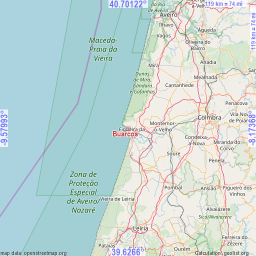
Buarcos GPS coordinates[2]
40° 9' 57.744" North, 8° 52' 36.48" West
| Map corner | latitude | longitude |
|---|---|---|
| Upper-left | 40.70122°, | -9.57993° |
| Center: | 40.16604°, | -8.8768° |
| Lower-right: | 39.6266°, | -8.17368° |
| Map W x H: | 119.5×119.5 km | = 74.3×74.3mi |
| max Lat: | 42.11337° ⇑44.8% North |
| Buarcos: | 40.16604° |
| min Lat: | ⇓55.2% South 32.6448° |
| min Long | Buarcos | max Long |
| -31.17847° | -8.8768° | -6.27308° |
| W 29.1%⇐ | ⇒70.9% E |
Elevation
Elevation of Buarcos is 25 m = 82 ft, and this is 152 m = 499 ft below average elevation for this country.
| Max E: |
1008 m = 3307 ft | 84% |
| Avg. | 177 m = 581 ft | |
| Buarcos | 25 m = 82 ft | |
Min E: |
-128 m = -420 ft | 16% |
See also: Portugal elevation on elevation.city.
Geographical zone
Buarcos is located in North temperate zone (between Tropic of Cancer and the Arctic Circle). Distance of this Northern Tropic circle is 1860.1 km =1155.8 mi to South.| Distance of | km | miles | from Buarcos |
|---|---|---|---|
| North Pole | 5541 | 3443 | to North |
| Arctic Circle | 2935.1 | 1823.8 | to North |
| Tropic Cancer | 1860.1 | 1155.8 | to South |
| Equator | 4466 | 2775 | to South |


Nearby cities:
15 places around Buarcos: (largest is in red/bold)
• Alfarelos
19.1 km =11.9 mi,  95°
95°
• Alhadas
7.7 km =4.8 mi,  73°
73°
• Ançã
32.4 km =20.1 mi, 68°
• Arazede
23.4 km =14.5 mi,  55°
55°
• Cantanhede
31.3 km =19.4 mi,  50°
50°
• Carapinheira
19.9 km =12.4 mi,  77°
77°
• Figueira da Foz
2.1 km =1.3 mi,  142°
142°
• Lavos
9 km =5.6 mi,  152°
152°
• Louriçal
21.6 km =13.4 mi, 146°
• Mira
31.5 km =19.6 mi,  22°
22°
• Monte Redondo
29.9 km =18.6 mi,  172°
172°
• Montemor-o-Velho
16.2 km =10.1 mi,  87°
87°
• Soure
24.4 km =15.2 mi,  118°
118°
• Tavarede
2.6 km =1.6 mi, 87°
• Tocha
19.4 km =12.1 mi,  32°
32°
Sources, notices
• [Note1] Compared only with cities in Portugal existing in our database
• [Src1] Map data: © OpenStreetMap contributors (CC-BY-SA)
• [Src2] Other city data from geonames.org with taken over terms of usage.
• [Src3] Geographical zone / Annual Mean Temperature by Robert A. Rohde @ Wikipedia
