Tocha geodata
Tocha (Coimbra) is a populated place; located in Portugal in Europe/Lisbon (GMT+1) time zone. With population of 3,992 people, there are 522 cities with bigger population in this country. Compared to other cities in Portugal, 57.9% of cities are located further ↓South; 66% of cities are located further →East and 63.9% of cities have higher elevation than Tocha. Note1


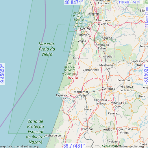
Tocha GPS coordinates[2]
40° 18' 47.088" North, 8° 45' 12.204" West
| Map corner | latitude | longitude |
|---|---|---|
| Upper-left | 40.8471°, | -9.45652° |
| Center: | 40.31308°, | -8.75339° |
| Lower-right: | 39.77481°, | -8.05027° |
| Map W x H: | 119.2×119.2 km | = 74.1×74.1mi |
| max Lat: | 42.11337° ⇑42.1% North |
| Tocha: | 40.31308° |
| min Lat: | ⇓57.9% South 32.6448° |
| min Long | Tocha | max Long |
| -31.17847° | -8.75339° | -6.27308° |
| W 34%⇐ | ⇒66% E |
Elevation
Elevation of Tocha is 66 m = 217 ft, and this is 111 m = 364 ft below average elevation for this country.
| Max E: |
1008 m = 3307 ft | 63.9% |
| Avg. | 177 m = 581 ft | |
| Tocha | 66 m = 217 ft | |
Min E: |
-128 m = -420 ft | 36.1% |
See also: Portugal elevation on elevation.city.
Geographical zone
Tocha is located in North temperate zone (between Tropic of Cancer and the Arctic Circle). Distance of this Northern Tropic circle is 1876.5 km =1166 mi to South.| Distance of | km | miles | from Tocha |
|---|---|---|---|
| North Pole | 5524.7 | 3432.9 | to North |
| Arctic Circle | 2918.8 | 1813.7 | to North |
| Tropic Cancer | 1876.5 | 1166 | to South |
| Equator | 4482.4 | 2785.2 | to South |


Nearby cities:
15 places around Tocha: (largest is in red/bold)
• Alfarelos
20 km =12.4 mi,  154°
154°
• Alhadas
14.5 km =9 mi,  192°
192°
• Ançã
20.2 km =12.6 mi,  103°
103°
• Arazede
9.3 km =5.8 mi,  108°
108°
• Buarcos
19.4 km =12.1 mi,  212°
212°
• Cantanhede
14 km =8.7 mi,  74°
74°
• Carapinheira
14.9 km =9.3 mi,  143°
143°
• Figueira da Foz
20.2 km =12.6 mi, 207°
• Lavos
25.2 km =15.7 mi, 194°
• Mealhada
26.7 km =16.6 mi, 74°
• Mira
13 km =8.1 mi,  5°
5°
• Montemor-o-Velho
16.6 km =10.3 mi,  159°
159°
• Pampilhosa do Botão
27.8 km =17.3 mi,  84°
84°
• Tavarede
18 km =11.2 mi, 205°
• Vagos
27.7 km =17.2 mi, 12°
Sources, notices
• [Note1] Compared only with cities in Portugal existing in our database
• [Src1] Map data: © OpenStreetMap contributors (CC-BY-SA)
• [Src2] Other city data from geonames.org with taken over terms of usage.
• [Src3] Geographical zone / Annual Mean Temperature by Robert A. Rohde @ Wikipedia
