Arazede geodata
Arazede (Coimbra) is a populated place; located in Portugal in Europe/Lisbon (GMT+1) time zone. With population of 5,906 people, there are 368 cities with bigger population in this country. Compared to other cities in Portugal, 57.5% of cities are located further ↓South; 58.9% of cities are located further →East and 56.2% of cities have higher elevation than Arazede. Note1


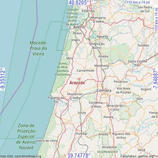
Arazede GPS coordinates[2]
40° 17' 10.572" North, 8° 38' 59.964" West
| Map corner | latitude | longitude |
|---|---|---|
| Upper-left | 40.8205°, | -9.35312° |
| Center: | 40.28627°, | -8.64999° |
| Lower-right: | 39.74778°, | -7.94687° |
| Map W x H: | 119.3×119.3 km | = 74.1×74.1mi |
| max Lat: | 42.11337° ⇑42.5% North |
| Arazede: | 40.28627° |
| min Lat: | ⇓57.5% South 32.6448° |
| min Long | Arazede | max Long |
| -31.17847° | -8.64999° | -6.27308° |
| W 41.1%⇐ | ⇒58.9% E |
Elevation
Elevation of Arazede is 89 m = 292 ft, and this is 88 m = 289 ft below average elevation for this country.
| Max E: |
1008 m = 3307 ft | 56.2% |
| Avg. | 177 m = 581 ft | |
| Arazede | 89 m = 292 ft | |
Min E: |
-128 m = -420 ft | 43.8% |
See also: Portugal elevation on elevation.city.
Geographical zone
Arazede is located in North temperate zone (between Tropic of Cancer and the Arctic Circle). Distance of this Northern Tropic circle is 1873.5 km =1164.1 mi to South.| Distance of | km | miles | from Arazede |
|---|---|---|---|
| North Pole | 5527.6 | 3434.7 | to North |
| Arctic Circle | 2921.8 | 1815.5 | to North |
| Tropic Cancer | 1873.5 | 1164.1 | to South |
| Equator | 4479.4 | 2783.4 | to South |


Nearby cities:
15 places around Arazede: (largest is in red/bold)
• Alfarelos
15.1 km =9.4 mi,  181°
181°
• Alhadas
16.3 km =10.1 mi,  226°
226°
• Ançã
11.1 km =6.9 mi,  98°
98°
• Cantanhede
8.2 km =5.1 mi,  35°
35°
• Carapinheira
8.9 km =5.5 mi, 178°
• Coimbra
21.5 km =13.4 mi,  114°
114°
• Condeixa-a-Nova
23.2 km =14.4 mi,  146°
146°
• Mealhada
19.8 km =12.3 mi,  58°
58°
• Mira
17.5 km =10.9 mi,  334°
334°
• Montemor-o-Velho
13 km =8.1 mi,  193°
193°
• Pampilhosa do Botão
19.7 km =12.2 mi,  73°
73°
• Santa Clara
20.2 km =12.6 mi,  118°
118°
• Santo António dos Olivais
22.1 km =13.7 mi, 110°
• Tavarede
21.3 km =13.2 mi, 231°
• Tocha
9.3 km =5.8 mi,  288°
288°
Sources, notices
• [Note1] Compared only with cities in Portugal existing in our database
• [Src1] Map data: © OpenStreetMap contributors (CC-BY-SA)
• [Src2] Other city data from geonames.org with taken over terms of usage.
• [Src3] Geographical zone / Annual Mean Temperature by Robert A. Rohde @ Wikipedia
