Cantanhede geodata
Cantanhede (Coimbra) is a seat of a second-order administrative division; located in Portugal in Europe/Lisbon (GMT+1) time zone. With population of 7,347 people, there are 305 cities with bigger population in this country. Compared to other cities in Portugal, 58.7% of cities are located further ↓South; 53.4% of cities are located further →East and 64.7% of cities have higher elevation than Cantanhede. Note1


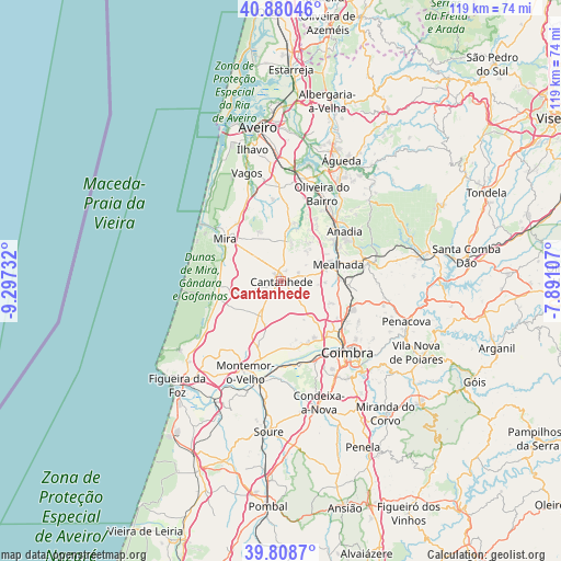
Cantanhede GPS coordinates[2]
40° 20' 48.156" North, 8° 35' 39.084" West
| Map corner | latitude | longitude |
|---|---|---|
| Upper-left | 40.88046°, | -9.29732° |
| Center: | 40.34671°, | -8.59419° |
| Lower-right: | 39.8087°, | -7.89107° |
| Map W x H: | 119.2×119.2 km | = 74.1×74.1mi |
| max Lat: | 42.11337° ⇑41.3% North |
| Cantanhede: | 40.34671° |
| min Lat: | ⇓58.7% South 32.6448° |
| min Long | Cantanhede | max Long |
| -31.17847° | -8.59419° | -6.27308° |
| W 46.6%⇐ | ⇒53.4% E |
Elevation
Elevation of Cantanhede is 63 m = 207 ft, and this is 114 m = 374 ft below average elevation for this country.
| Max E: |
1008 m = 3307 ft | 64.7% |
| Avg. | 177 m = 581 ft | |
| Cantanhede | 63 m = 207 ft | |
Min E: |
-128 m = -420 ft | 35.3% |
See also: Portugal elevation on elevation.city.
Geographical zone
Cantanhede is located in North temperate zone (between Tropic of Cancer and the Arctic Circle). Distance of this Northern Tropic circle is 1880.2 km =1168.3 mi to South.| Distance of | km | miles | from Cantanhede |
|---|---|---|---|
| North Pole | 5520.9 | 3430.5 | to North |
| Arctic Circle | 2915 | 1811.3 | to North |
| Tropic Cancer | 1880.2 | 1168.3 | to South |
| Equator | 4486.1 | 2787.5 | to South |


Nearby cities:
15 places around Cantanhede: (largest is in red/bold)
• Anadia
17 km =10.6 mi,  53°
53°
• Ançã
10.4 km =6.5 mi,  143°
143°
• Arazede
8.2 km =5.1 mi,  215°
215°
• Arcos
17.1 km =10.6 mi, 48°
• Carapinheira
16.3 km =10.1 mi,  196°
196°
• Luso
18.7 km =11.6 mi,  77°
77°
• Mealhada
12.7 km =7.9 mi,  74°
74°
• Mira
15.2 km =9.4 mi,  306°
306°
• Montemor-o-Velho
20.8 km =12.9 mi, 201°
• Oliveira do Bairro
20.5 km =12.7 mi,  24°
24°
• Pampilhosa do Botão
14.2 km =8.8 mi,  94°
94°
• Sangalhos
18.8 km =11.7 mi,  34°
34°
• Santa Clara
20.9 km =13 mi, 141°
• Santo António dos Olivais
21.5 km =13.4 mi,  131°
131°
• Tocha
14 km =8.7 mi,  254°
254°
Sources, notices
• [Note1] Compared only with cities in Portugal existing in our database
• [Src1] Map data: © OpenStreetMap contributors (CC-BY-SA)
• [Src2] Other city data from geonames.org with taken over terms of usage.
• [Src3] Geographical zone / Annual Mean Temperature by Robert A. Rohde @ Wikipedia
