Carapeguá geodata
Carapeguá (Paraguarí) is a populated place; located in Paraguay in America/Asuncion (GMT-4) time zone. With population of 5,784 people, there are 51 cities with bigger population in this country. Compared to other cities in Paraguay, 63.6% of cities are located further ↑North; 74.7% of cities are located further →East and 88.3% of cities have lower elevation than Carapeguá. Note1


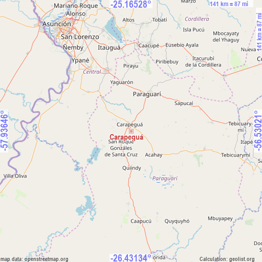
Carapeguá GPS coordinates[2]
25° 48' 0" South, 57° 13' 59.988" West
| Map corner | latitude | longitude |
|---|---|---|
| Upper-left | -25.16528°, | -57.93646° |
| Center: | -25.8°, | -57.23333° |
| Lower-right: | -26.43134°, | -56.53021° |
| Map W x H: | 140.8×140.8 km | = 87.5×87.5mi |
| max Lat: | -19.91667° ⇑63.6% North |
| Carapeguá: | -25.8° |
| min Lat: | ⇓36.4% South -27.38662° |
| min Long | Carapeguá | max Long |
| -60.78333° | -57.23333° | -54.30694° |
| W 25.3%⇐ | ⇒74.7% E |
Elevation
Elevation of Carapeguá is 292 m = 958 ft, and this is 122.3 m = 401 ft above average elevation for this country.
| Max E: |
658 m = 2159 ft | 11.7% |
| Carapeguá | 292 m 958 ft | |
| Avg. | 169.7 m = 557 ft | |
Min E: |
46 m = 151 ft | 88.3% |
See also: Paraguay elevation on elevation.city.
Geographical zone
Carapeguá is located in South temperate zone (between Tropic of Capricorn and the Antarctic Circle). Distance of this Southern Tropic circle is 262.8 km =163.3 mi to North.| Distance of | km | miles | from Carapeguá |
|---|---|---|---|
| Equator | 2868.7 | 1782.5 | to North |
| Tropic Capricorn | 262.8 | 163.3 | to North |
| Antarctic Circle | 4532.5 | 2816.4 | to South |
| South Pole | 7138.4 | 4435.6 | to South |


Nearby cities:
15 places around Carapeguá: (largest is in red/bold)
• Acahay
15.4 km =9.6 mi,  147°
147°
• Guarambaré
41 km =25.5 mi,  327°
327°
• Itá
35.9 km =22.3 mi,  338°
338°
• La Colmena
40.4 km =25.1 mi,  103°
103°
• Nueva Italia
31.4 km =19.5 mi,  312°
312°
• Paraguarí
21.7 km =13.5 mi,  23°
23°
• Pirayú
35.1 km =21.8 mi,  359°
359°
• Piribebuy
41.9 km =26 mi,  27°
27°
• Quiindy
19.6 km =12.2 mi,  180°
180°
• Sapucaí
31.8 km =19.8 mi,  62°
62°
• Valenzuela
42.8 km =26.6 mi, 58°
• Yaguarón
27 km =16.8 mi,  349°
349°
• Ybycuí
30.3 km =18.8 mi,  142°
142°
• Ybytymi
43.4 km =27 mi,  83°
83°
• Ypacarai
44 km =27.3 mi, 352°
Sources, notices
• [Note1] Compared only with cities in Paraguay existing in our database
• [Src1] Map data: © OpenStreetMap contributors (CC-BY-SA)
• [Src2] Other city data from geonames.org with taken over terms of usage.
• [Src3] Geographical zone / Annual Mean Temperature by Robert A. Rohde @ Wikipedia
