Pedro Juan Caballero geodata
Pedro Juan Caballero (Amambay) is a seat of a first-order administrative division; located in Paraguay in America/Asuncion (GMT-4) time zone. With population of 75,109 people, there are 8 cities with bigger population in this country. Compared to other cities in Paraguay, 95.7% of cities are located further ↓South; 79.6% of cities are located further ←West and 100% of cities have lower elevation than Pedro Juan Caballero. Note1


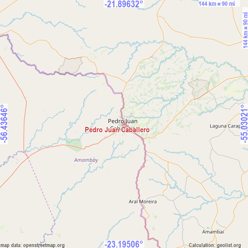
Pedro Juan Caballero GPS coordinates[2]
22° 32' 49.992" South, 55° 43' 59.988" West
| Map corner | latitude | longitude |
|---|---|---|
| Upper-left | -21.89632°, | -56.43646° |
| Center: | -22.54722°, | -55.73333° |
| Lower-right: | -23.19506°, | -55.03021° |
| Map W x H: | 144.4×144.4 km | = 89.7×89.7mi |
| max Lat: | -19.91667° ⇑4.3% North |
| Pedro Juan Caballero: | -22.54722° |
| min Lat: | ⇓95.7% South -27.38662° |
| min Long | Pedro Juan Caba | max Long |
| -60.78333° | -55.73333° | -54.30694° |
| W 79.6%⇐ | ⇒20.4% E |
Elevation
Elevation of Pedro Juan Caballero is 658 m = 2159 ft, and this is 488.3 m = 1602 ft above average elevation for this country.
| Max E: |
658 m = 2159 ft | 0% |
| Pedro Juan Caballero | 658 m 2159 ft | |
| Avg. | 169.7 m = 557 ft | |
Min E: |
46 m = 151 ft | 100% |
See also: Pedro Juan Caballero elevation on elevation.city.
Geographical zone
Pedro Juan Caballero is located in South Torrid zone (between Equator and Tropic of Capricorn). Distance of this Southern Tropic circle is 98.9 km =61.5 mi to South.| Distance of | km | miles | from Pedro Juan Caballero |
|---|---|---|---|
| Equator | 2507 | 1557.8 | to North |
| Tropic Capricorn | 98.9 | 61.5 | to South |
| Antarctic Circle | 4894.2 | 3041.1 | to South |
| South Pole | 7500 | 4660.3 | to South |


Nearby cities:
15 places around Pedro Juan Caballero: (largest is in red/bold)
• Bella Vista
92.8 km =57.7 mi,  299°
299°
• Belén
186.9 km =116.1 mi,  236°
236°
• Capitán Bado
82.6 km =51.3 mi,  165°
165°
• Chore
201.8 km =125.4 mi,  205°
205°
• Colonia Catuete
210 km =130.5 mi,  147°
147°
• Colonia Nueva Germania
181.1 km =112.5 mi, 213°
• Concepción
198.1 km =123.1 mi, 241°
• Corpus Christi
188.8 km =117.3 mi, 154°
• Horqueta
162.1 km =100.7 mi, 236°
• La Paloma
209.8 km =130.4 mi, 146°
• Lima
167.1 km =103.8 mi, 207°
• San Carlos
164 km =101.9 mi,  280°
280°
• San Isidro de Curuguaty
214 km =133 mi,  178°
178°
• Tacuatí
132.8 km =82.5 mi,  220°
220°
• Ygatimi
175.5 km =109.1 mi, 177°
Sources, notices
• [Note1] Compared only with cities in Paraguay existing in our database
• [Src1] Map data: © OpenStreetMap contributors (CC-BY-SA)
• [Src2] Other city data from geonames.org with taken over terms of usage.
• [Src3] Geographical zone / Annual Mean Temperature by Robert A. Rohde @ Wikipedia
