Horqueta geodata
Horqueta (Concepción) is a populated place; located in Paraguay in America/Asuncion (GMT-4) time zone. With population of 10,531 people, there are 31 cities with bigger population in this country. Compared to other cities in Paraguay, 93.8% of cities are located further ↓South; 66% of cities are located further →East and 61.1% of cities have lower elevation than Horqueta. Note1


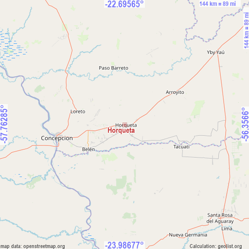
Horqueta GPS coordinates[2]
23° 20' 34.008" South, 57° 3' 34.992" West
| Map corner | latitude | longitude |
|---|---|---|
| Upper-left | -22.69565°, | -57.76285° |
| Center: | -23.34278°, | -57.05972° |
| Lower-right: | -23.98677°, | -56.3566° |
| Map W x H: | 143.6×143.6 km | = 89.2×89.2mi |
| max Lat: | -19.91667° ⇑6.2% North |
| Horqueta: | -23.34278° |
| min Lat: | ⇓93.8% South -27.38662° |
| min Long | Horqueta | max Long |
| -60.78333° | -57.05972° | -54.30694° |
| W 34%⇐ | ⇒66% E |
Elevation
Elevation of Horqueta is 165 m = 541 ft, and this is 4.7 m = 15 ft below average elevation for this country.
| Max E: |
658 m = 2159 ft | 38.9% |
| Avg. | 169.7 m = 557 ft | |
| Horqueta | 165 m = 541 ft | |
Min E: |
46 m = 151 ft | 61.1% |
See also: Paraguay elevation on elevation.city.
Geographical zone
Horqueta is located in South Torrid zone (between Equator and Tropic of Capricorn). Distance of this Southern Tropic circle is 10.4 km =6.5 mi to South.| Distance of | km | miles | from Horqueta |
|---|---|---|---|
| Equator | 2595.5 | 1612.8 | to North |
| Tropic Capricorn | 10.4 | 6.5 | to South |
| Antarctic Circle | 4805.7 | 2986.1 | to South |
| South Pole | 7411.6 | 4605.4 | to South |


Nearby cities:
15 places around Horqueta: (largest is in red/bold)
• Antequera
83.8 km =52.1 mi,  189°
189°
• Bella Vista
145.6 km =90.5 mi,  22°
22°
• Belén
24.8 km =15.4 mi,  236°
236°
• Chore
105.6 km =65.6 mi,  152°
152°
• Colonia Nueva Germania
73 km =45.4 mi, 149°
• Concepción
38.6 km =24 mi,  260°
260°
• General Elizardo Aquino
123.5 km =76.7 mi,  172°
172°
• Guayaybi
146.9 km =91.3 mi, 154°
• Itacurubí del Rosario
134.8 km =83.8 mi, 169°
• Lima
84.1 km =52.3 mi,  135°
135°
• Puerto Rosario
122.4 km =76.1 mi,  183°
183°
• San Carlos
122.2 km =75.9 mi,  348°
348°
• San Pablo de Ycuámandyyú
89.8 km =55.8 mi, 180°
• San Pedro de Ycuamandiyú
82.6 km =51.3 mi, 181°
• Tacuatí
50.1 km =31.1 mi,  103°
103°
Sources, notices
• [Note1] Compared only with cities in Paraguay existing in our database
• [Src1] Map data: © OpenStreetMap contributors (CC-BY-SA)
• [Src2] Other city data from geonames.org with taken over terms of usage.
• [Src3] Geographical zone / Annual Mean Temperature by Robert A. Rohde @ Wikipedia
