Belén geodata
Belén (Concepción) is a populated place; located in Paraguay in America/Asuncion (GMT-4) time zone. With population of 1,621 people, there are 121 cities with bigger population in this country. Compared to other cities in Paraguay, 92% of cities are located further ↓South; 77.2% of cities are located further →East and 82.7% of cities have higher elevation than Belén. Note1


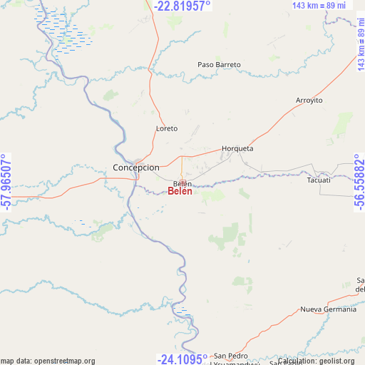
Belén GPS coordinates[2]
23° 27' 57.996" South, 57° 15' 42.984" West
| Map corner | latitude | longitude |
|---|---|---|
| Upper-left | -22.81957°, | -57.96507° |
| Center: | -23.46611°, | -57.26194° |
| Lower-right: | -24.1095°, | -56.55882° |
| Map W x H: | 143.4×143.4 km | = 89.1×89.1mi |
| max Lat: | -19.91667° ⇑8% North |
| Belén: | -23.46611° |
| min Lat: | ⇓92% South -27.38662° |
| min Long | Belén | max Long |
| -60.78333° | -57.26194° | -54.30694° |
| W 22.8%⇐ | ⇒77.2% E |
Elevation
Elevation of Belén is 100 m = 328 ft, and this is 69.7 m = 229 ft below average elevation for this country.
| Max E: |
658 m = 2159 ft | 82.7% |
| Avg. | 169.7 m = 557 ft | |
| Belén | 100 m = 328 ft | |
Min E: |
46 m = 151 ft | 17.3% |
See also: Paraguay elevation on elevation.city.
Geographical zone
Belén is located in South temperate zone (between Tropic of Capricorn and the Antarctic Circle). Distance of this Southern Tropic circle is 3.3 km =2.1 mi to North.| Distance of | km | miles | from Belén |
|---|---|---|---|
| Equator | 2609.2 | 1621.3 | to North |
| Tropic Capricorn | 3.3 | 2.1 | to North |
| Antarctic Circle | 4792 | 2977.6 | to South |
| South Pole | 7397.9 | 4596.8 | to South |


Nearby cities:
15 places around Belén: (largest is in red/bold)
• Antequera
69.1 km =42.9 mi,  174°
174°
• Chore
105.8 km =65.7 mi,  139°
139°
• Colonia Nueva Germania
75.6 km =47 mi,  130°
130°
• Concepción
18.9 km =11.7 mi,  292°
292°
• General Elizardo Aquino
114.8 km =71.3 mi,  161°
161°
• Guayaybi
145.5 km =90.4 mi, 144°
• Horqueta
24.8 km =15.4 mi,  56°
56°
• Itacurubí del Rosario
127 km =78.9 mi, 159°
• Lima
92 km =57.2 mi,  120°
120°
• Puerto Rosario
109.1 km =67.8 mi, 173°
• San Carlos
133.4 km =82.9 mi,  358°
358°
• San Pablo de Ycuámandyyú
78.6 km =48.8 mi, 165°
• San Pedro de Ycuamandiyú
71.1 km =44.2 mi, 165°
• Tacuatí
69.2 km =43 mi,  88°
88°
• Veinticinco de Diciembre
155.1 km =96.4 mi,  152°
152°
Sources, notices
• [Note1] Compared only with cities in Paraguay existing in our database
• [Src1] Map data: © OpenStreetMap contributors (CC-BY-SA)
• [Src2] Other city data from geonames.org with taken over terms of usage.
• [Src3] Geographical zone / Annual Mean Temperature by Robert A. Rohde @ Wikipedia
