Nueva Esperanza geodata
Nueva Esperanza (Canindeyú) is a populated place; located in Paraguay in America/Asuncion (GMT-4) time zone. With population of 12,717 people, there are 25 cities with bigger population in this country. Compared to other cities in Paraguay, 82.7% of cities are located further ↓South; 93.8% of cities are located further ←West and 97.5% of cities have lower elevation than Nueva Esperanza. Note1


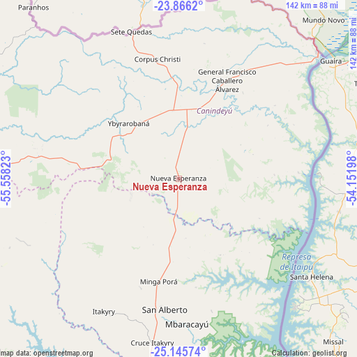
Nueva Esperanza GPS coordinates[2]
24° 30' 27.36" South, 54° 51' 18.36" West
| Map corner | latitude | longitude |
|---|---|---|
| Upper-left | -23.8662°, | -55.55823° |
| Center: | -24.5076°, | -54.8551° |
| Lower-right: | -25.14574°, | -54.15198° |
| Map W x H: | 142.3×142.3 km | = 88.4×88.4mi |
| max Lat: | -19.91667° ⇑17.3% North |
| Nueva Esperanza: | -24.5076° |
| min Lat: | ⇓82.7% South -27.38662° |
| min Long | Nueva Esperanza | max Long |
| -60.78333° | -54.8551° | -54.30694° |
| W 93.8%⇐ | ⇒6.2% E |
Elevation
Elevation of Nueva Esperanza is 370 m = 1214 ft, and this is 200.3 m = 657 ft above average elevation for this country.
| Max E: |
658 m = 2159 ft | 2.5% |
| Nueva Esperanza | 370 m 1214 ft | |
| Avg. | 169.7 m = 557 ft | |
Min E: |
46 m = 151 ft | 97.5% |
See also: Paraguay elevation on elevation.city.
Geographical zone
Nueva Esperanza is located in South temperate zone (between Tropic of Capricorn and the Antarctic Circle). Distance of this Southern Tropic circle is 119.1 km =74 mi to North.| Distance of | km | miles | from Nueva Esperanza |
|---|---|---|---|
| Equator | 2725 | 1693.2 | to North |
| Tropic Capricorn | 119.1 | 74 | to North |
| Antarctic Circle | 4676.2 | 2905.7 | to South |
| South Pole | 7282.1 | 4524.9 | to South |


Nearby cities:
15 places around Nueva Esperanza: (largest is in red/bold)
• Capiíbary
123.4 km =76.7 mi,  254°
254°
• Ciudad del Este
114.1 km =70.9 mi,  167°
167°
• Colonia Catuete
48.1 km =29.9 mi,  30°
30°
• Colonia Minga Porá
40.2 km =25 mi,  186°
186°
• Corpus Christi
48.3 km =30 mi,  349°
349°
• Doctor Juan León Mallorquín
110.2 km =68.5 mi,  201°
201°
• Itakyry
61 km =37.9 mi,  209°
209°
• La Paloma
48.6 km =30.2 mi, 30°
• Presidente Franco
120 km =74.6 mi, 168°
• Salto del Guairá
74.4 km =46.2 mi,  48°
48°
• San Alberto
51.2 km =31.8 mi, 185°
• San Isidro de Curuguaty
84.8 km =52.7 mi,  272°
272°
• Ygatimi
90.6 km =56.3 mi,  298°
298°
• Yguazú
107.1 km =66.5 mi, 187°
• Yhú
123.9 km =77 mi,  240°
240°
Sources, notices
• [Note1] Compared only with cities in Paraguay existing in our database
• [Src1] Map data: © OpenStreetMap contributors (CC-BY-SA)
• [Src2] Other city data from geonames.org with taken over terms of usage.
• [Src3] Geographical zone / Annual Mean Temperature by Robert A. Rohde @ Wikipedia
