San Alberto geodata
San Alberto (Alto Paraná) is a seat of a second-order administrative division; located in Paraguay in America/Asuncion (GMT-4) time zone. With population of 4,989 people, there are 61 cities with bigger population in this country. Compared to other cities in Paraguay, 77.2% of cities are located further ↓South; 92.6% of cities are located further ←West and 95.1% of cities have lower elevation than San Alberto. Note1


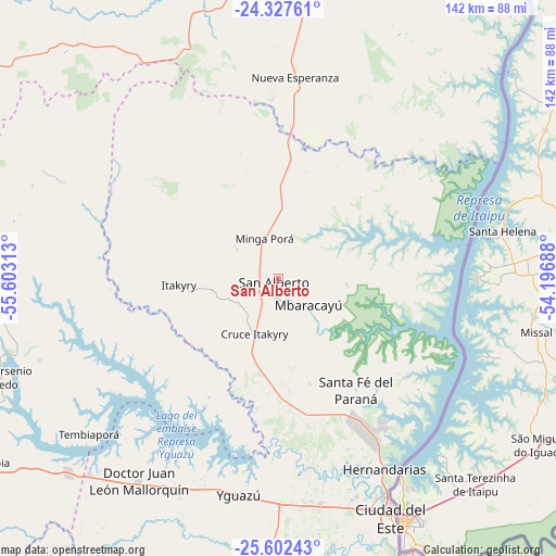
San Alberto GPS coordinates[2]
24° 58' 0.012" South, 54° 54' 0" West
| Map corner | latitude | longitude |
|---|---|---|
| Upper-left | -24.32761°, | -55.60313° |
| Center: | -24.96667°, | -54.9° |
| Lower-right: | -25.60243°, | -54.19688° |
| Map W x H: | 141.7×141.7 km | = 88×88mi |
| max Lat: | -19.91667° ⇑22.8% North |
| San Alberto: | -24.96667° |
| min Lat: | ⇓77.2% South -27.38662° |
| min Long | San Alberto | max Long |
| -60.78333° | -54.9° | -54.30694° |
| W 92.6%⇐ | ⇒7.4% E |
Elevation
Elevation of San Alberto is 346 m = 1135 ft, and this is 176.3 m = 578 ft above average elevation for this country.
| Max E: |
658 m = 2159 ft | 4.9% |
| San Alberto | 346 m 1135 ft | |
| Avg. | 169.7 m = 557 ft | |
Min E: |
46 m = 151 ft | 95.1% |
See also: Paraguay elevation on elevation.city.
Geographical zone
San Alberto is located in South temperate zone (between Tropic of Capricorn and the Antarctic Circle). Distance of this Southern Tropic circle is 170.1 km =105.7 mi to North.| Distance of | km | miles | from San Alberto |
|---|---|---|---|
| Equator | 2776 | 1724.9 | to North |
| Tropic Capricorn | 170.1 | 105.7 | to North |
| Antarctic Circle | 4625.1 | 2873.9 | to South |
| South Pole | 7231 | 4493.1 | to South |


Nearby cities:
15 places around San Alberto: (largest is in red/bold)
• Cedrales
78.8 km =49 mi,  166°
166°
• Ciudad del Este
67 km =41.6 mi,  154°
154°
• Colonia Catuete
97 km =60.3 mi,  17°
17°
• Colonia General Alfredo Stroessner
92.4 km =57.4 mi,  241°
241°
• Colonia Minga Porá
11.1 km =6.9 mi,  0°
0°
• Corpus Christi
98.6 km =61.3 mi,  357°
357°
• Doctor Juan León Mallorquín
62.7 km =39 mi,  214°
214°
• Itakyry
25.3 km =15.7 mi,  265°
265°
• La Paloma
97.5 km =60.6 mi, 17°
• Nueva Esperanza
51.2 km =31.8 mi,  5°
5°
• Presidente Franco
72.5 km =45 mi,  156°
156°
• San Isidro de Curuguaty
97.1 km =60.3 mi,  304°
304°
• Santa Rita
92.3 km =57.4 mi,  190°
190°
• Yguazú
56 km =34.8 mi, 190°
• Yhú
103.5 km =64.3 mi,  264°
264°
Sources, notices
• [Note1] Compared only with cities in Paraguay existing in our database
• [Src1] Map data: © OpenStreetMap contributors (CC-BY-SA)
• [Src2] Other city data from geonames.org with taken over terms of usage.
• [Src3] Geographical zone / Annual Mean Temperature by Robert A. Rohde @ Wikipedia
