Presidente Franco geodata
Presidente Franco (Alto Paraná) is a populated place; located in Paraguay in America/Asuncion (GMT-4) time zone. With population of 54,292 people, there are 16 cities with bigger population in this country. Compared to other cities in Paraguay, 54.3% of cities are located further ↑North; 99.4% of cities are located further ←West and 77.2% of cities have lower elevation than Presidente Franco. Note1


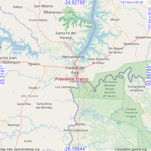
Presidente Franco GPS coordinates[2]
25° 33' 49.824" South, 54° 36' 39.492" West
| Map corner | latitude | longitude |
|---|---|---|
| Upper-left | -24.92788°, | -55.3141° |
| Center: | -25.56384°, | -54.61097° |
| Lower-right: | -26.19644°, | -53.90785° |
| Map W x H: | 141.1×141.1 km | = 87.7×87.7mi |
| max Lat: | -19.91667° ⇑54.3% North |
| Presidente Franco: | -25.56384° |
| min Lat: | ⇓45.7% South -27.38662° |
| min Long | Presidente Fran | max Long |
| -60.78333° | -54.61097° | -54.30694° |
| W 99.4%⇐ | ⇒0.59999999999999% E |
Elevation
Elevation of Presidente Franco is 206 m = 676 ft, and this is 36.3 m = 119 ft above average elevation for this country.
| Max E: |
658 m = 2159 ft | 22.8% |
| Presidente Franco | 206 m 676 ft | |
| Avg. | 169.7 m = 557 ft | |
Min E: |
46 m = 151 ft | 77.2% |
See also: Presidente Franco elevation on elevation.city.
Geographical zone
Presidente Franco is located in South temperate zone (between Tropic of Capricorn and the Antarctic Circle). Distance of this Southern Tropic circle is 236.5 km =147 mi to North.| Distance of | km | miles | from Presidente Franco |
|---|---|---|---|
| Equator | 2842.4 | 1766.2 | to North |
| Tropic Capricorn | 236.5 | 147 | to North |
| Antarctic Circle | 4558.7 | 2832.6 | to South |
| South Pole | 7164.6 | 4451.9 | to South |


Nearby cities:
15 places around Presidente Franco: (largest is in red/bold)
• Cedrales
15.2 km =9.4 mi,  227°
227°
• Ciudad del Este
6 km =3.7 mi,  359°
359°
• Colonia Carlos Antonio López
93.9 km =58.3 mi,  188°
188°
• Colonia General Alfredo Stroessner
112.2 km =69.7 mi,  281°
281°
• Colonia Minga Porá
82.8 km =51.4 mi,  339°
339°
• Colonia San Lorenzo
105 km =65.2 mi, 190°
• Doctor Juan León Mallorquín
66.2 km =41.1 mi, 282°
• Itakyry
84 km =52.2 mi,  319°
319°
• Naranjal
72.7 km =45.2 mi, 231°
• Nueva Esperanza
120 km =74.6 mi,  348°
348°
• Puerto Mayor Otaño
93.4 km =58 mi, 185°
• San Alberto
72.5 km =45 mi, 336°
• Santa Rita
51.8 km =32.2 mi,  241°
241°
• Yguazú
40.7 km =25.3 mi,  286°
286°
• Ñacunday
52.7 km =32.7 mi,  197°
197°
Sources, notices
• [Note1] Compared only with cities in Paraguay existing in our database
• [Src1] Map data: © OpenStreetMap contributors (CC-BY-SA)
• [Src2] Other city data from geonames.org with taken over terms of usage.
• [Src3] Geographical zone / Annual Mean Temperature by Robert A. Rohde @ Wikipedia
