Doctor Juan León Mallorquín geodata
Doctor Juan León Mallorquín (Alto Paraná) is a populated place; located in Paraguay in America/Asuncion (GMT-4) time zone. With population of 7,481 people, there are 44 cities with bigger population in this country. Compared to other cities in Paraguay, 53.7% of cities are located further ↓South; 87.7% of cities are located further ←West and 81.5% of cities have lower elevation than Doctor Juan León Mallorquín. Note1
Current local time in Doctor Juan León Mallorquín:
02:41 PM, ThursdayDifference from your time zone: hours


Doctor Juan León Mallorquín GPS coordinates[2]
25° 25' 49.908" South, 55° 15' 14.832" West
| Map corner | latitude | longitude |
|---|---|---|
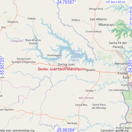
| Upper-left | -24.79387°, | -55.95725° |
| Center: | -25.43053°, | -55.25412° |
| Lower-right: | -26.06384°, | -54.551° |
| Map W x H: | 141.2×141.2 km | = 87.7×87.7mi |
| max Lat: | -19.91667° ⇑46.3% North |
| Doctor Juan León Mallorquín: | -25.43053° |
| min Lat: | ⇓53.7% South -27.38662° |
| min Long | Doctor Juan Le� | max Long |
| -60.78333° | -55.25412° | -54.30694° |
| W 87.7%⇐ | ⇒12.3% E |
Elevation
Elevation of Doctor Juan León Mallorquín is 247 m = 810 ft, and this is 77.3 m = 254 ft above average elevation for this country.
| Max E: |
658 m = 2159 ft | 18.5% |
| Doctor Juan León Mallorquín | 247 m 810 ft | |
| Avg. | 169.7 m = 557 ft | |
Min E: |
46 m = 151 ft | 81.5% |
See also: Paraguay elevation on elevation.city.
Geographical zone
Doctor Juan León Mallorquín is located in South temperate zone (between Tropic of Capricorn and the Antarctic Circle). Distance of this Southern Tropic circle is 221.7 km =137.8 mi to North.| Distance of | km | miles | from Doctor Juan León Mallorquín |
|---|---|---|---|
| Equator | 2827.6 | 1757 | to North |
| Tropic Capricorn | 221.7 | 137.8 | to North |
| Antarctic Circle | 4573.6 | 2841.9 | to South |
| South Pole | 7179.5 | 4461.1 | to South |


Nearby cities:
15 places around Doctor Juan León Mallorquín: (largest is in red/bold)
• Caaguazú
76.6 km =47.6 mi,  266°
266°
• Cedrales
58.9 km =36.6 mi,  115°
115°
• Ciudad del Este
65.1 km =40.5 mi,  97°
97°
• Colonia General Alfredo Stroessner
46.1 km =28.6 mi,  279°
279°
• Colonia Minga Porá
72.1 km =44.8 mi,  29°
29°
• Doctor Juan Manuel Frutos
58.3 km =36.2 mi, 275°
• Itakyry
50.5 km =31.4 mi,  12°
12°
• Naranjal
60 km =37.3 mi,  173°
173°
• Presidente Franco
66.2 km =41.1 mi, 102°
• Repatriación
70.8 km =44 mi,  260°
260°
• San Alberto
62.7 km =39 mi, 34°
• Santa Rita
43.5 km =27 mi,  154°
154°
• Yguazú
25.7 km =16 mi, 97°
• Yhú
79 km =49.1 mi,  301°
301°
• Ñacunday
81.4 km =50.6 mi,  143°
143°
Sources, notices
• [Note1] Compared only with cities in Paraguay existing in our database
• [Src1] Map data: © OpenStreetMap contributors (CC-BY-SA)
• [Src2] Other city data from geonames.org with taken over terms of usage.
• [Src3] Geographical zone / Annual Mean Temperature by Robert A. Rohde @ Wikipedia
