Subotica geodata
Subotica (Vojvodina) is a seat of a second-order administrative division; located in Serbia in Europe/Belgrade (GMT+2) time zone. With population of 100,000 people, there are 6 cities with bigger population in this country. Compared to other cities in Serbia, 100% of cities are located further ↓South; 79.4% of cities are located further →East and 61.9% of cities have lower elevation than Subotica. Note1


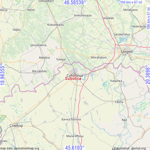
Subotica GPS coordinates[2]
46° 6' 0" North, 19° 40' 0.012" East
| Map corner | latitude | longitude |
|---|---|---|
| Upper-left | 46.58539°, | 18.96355° |
| Center: | 46.1°, | 19.66667° |
| Lower-right: | 45.6103°, | 20.3698° |
| Map W x H: | 108.4×108.4 km | = 67.4×67.4mi |
| max Lat: | 46.1° ⇑0% North |
| Subotica: | 46.1° |
| min Lat: | ⇓100% South 42.25846° |
| min Long | Subotica | max Long |
| 18.9276° | 19.66667° | 22.77556° |
| W 20.6%⇐ | ⇒79.4% E |
Elevation
Elevation of Subotica is 115 m = 377 ft, and this is 61.4 m = 201 ft below average elevation for this country.
| Max E: |
1421 m = 4662 ft | 38.1% |
| Avg. | 176.4 m = 579 ft | |
| Subotica | 115 m = 377 ft | |
Min E: |
49 m = 161 ft | 61.9% |
See also: Subotica elevation on elevation.city.
Geographical zone
Subotica is located in North temperate zone (between Tropic of Cancer and the Arctic Circle). Distance of this North polar circle is 2275.3 km =1413.8 mi to North.| Distance of | km | miles | from Subotica |
|---|---|---|---|
| North Pole | 4881.2 | 3033 | to North |
| Arctic Circle | 2275.3 | 1413.8 | to North |
| Tropic Cancer | 2519.9 | 1565.8 | to South |
| Equator | 5125.8 | 3185 | to South |


Nearby cities:
15 places around Subotica: (largest is in red/bold)
• Ada
48.5 km =30.1 mi,  132°
132°
• Adorjan
30.8 km =19.1 mi,  110°
110°
• Bačka Topola
31.8 km =19.8 mi,  184°
184°
• Gornji Breg
33.7 km =20.9 mi, 126°
• Jazovo
48.3 km =30 mi,  117°
117°
• Kanjiža
29.8 km =18.5 mi,  97°
97°
• Mali Iđoš
43.5 km =27 mi, 180°
• Novi Kneževac
33.9 km =21.1 mi, 99°
• Ostojićevo
45.2 km =28.1 mi, 121°
• Padej
48.9 km =30.4 mi, 128°
• Riđica
44.9 km =27.9 mi,  254°
254°
• Sanad
36.8 km =22.9 mi, 112°
• Senta
37.1 km =23.1 mi, 121°
• Stanišić
42.5 km =26.4 mi, 245°
• Čoka
40.8 km =25.4 mi, 115°
Sources, notices
• [Note1] Compared only with cities in Serbia existing in our database
• [Src1] Map data: © OpenStreetMap contributors (CC-BY-SA)
• [Src2] Other city data from geonames.org with taken over terms of usage.
• [Src3] Geographical zone / Annual Mean Temperature by Robert A. Rohde @ Wikipedia
