Bačka Topola geodata
Bačka Topola (Vojvodina) is a seat of a third-order administrative division; located in Serbia in Europe/Belgrade (GMT+2) time zone. With population of 16,154 people, there are 46 cities with bigger population in this country. Compared to other cities in Serbia, 94.6% of cities are located further ↓South; 81.6% of cities are located further →East and 53.3% of cities have lower elevation than Bačka Topola. Note1


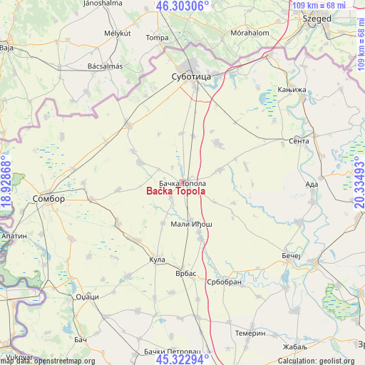
Bačka Topola GPS coordinates[2]
45° 48' 54.576" North, 19° 37' 54.48" East
| Map corner | latitude | longitude |
|---|---|---|
| Upper-left | 46.30306°, | 18.92868° |
| Center: | 45.81516°, | 19.6318° |
| Lower-right: | 45.32294°, | 20.33493° |
| Map W x H: | 109×109 km | = 67.7×67.7mi |
| max Lat: | 46.1° ⇑5.4% North |
| Bačka Topola: | 45.81516° |
| min Lat: | ⇓94.6% South 42.25846° |
| min Long | Bačka Topola | max Long |
| 18.9276° | 19.6318° | 22.77556° |
| W 18.4%⇐ | ⇒81.6% E |
Elevation
Elevation of Bačka Topola is 94 m = 308 ft, and this is 82.4 m = 270 ft below average elevation for this country.
| Max E: |
1421 m = 4662 ft | 46.7% |
| Avg. | 176.4 m = 579 ft | |
| Bačka Topola | 94 m = 308 ft | |
Min E: |
49 m = 161 ft | 53.3% |
See also: Serbia elevation on elevation.city.
Geographical zone
Bačka Topola is located in North temperate zone (between Tropic of Cancer and the Arctic Circle). Distance of this North polar circle is 2307 km =1433.5 mi to North.| Distance of | km | miles | from Bačka Topola |
|---|---|---|---|
| North Pole | 4912.9 | 3052.7 | to North |
| Arctic Circle | 2307 | 1433.5 | to North |
| Tropic Cancer | 2488.2 | 1546.1 | to South |
| Equator | 5094.2 | 3165.4 | to South |


Nearby cities:
15 places around Bačka Topola: (largest is in red/bold)
• Ada
38.3 km =23.8 mi,  92°
92°
• Adorjan
37.9 km =23.5 mi,  56°
56°
• Bačko Petrovo Selo
36.7 km =22.8 mi,  109°
109°
• Bečej
38.2 km =23.7 mi,  125°
125°
• Despotovo
40.3 km =25 mi,  191°
191°
• Gornji Breg
32.1 km =19.9 mi,  68°
68°
• Kula
24.4 km =15.2 mi,  199°
199°
• Mali Iđoš
12.2 km =7.6 mi,  167°
167°
• Mol
39.3 km =24.4 mi,  98°
98°
• Senta
36.7 km =22.8 mi, 70°
• Srbobran
31.9 km =19.8 mi,  155°
155°
• Stanišić
38.5 km =23.9 mi,  290°
290°
• Subotica
31.8 km =19.8 mi,  4°
4°
• Vrbas
27.1 km =16.8 mi,  178°
178°
• Zmajevo
40.4 km =25.1 mi, 173°
Sources, notices
• [Note1] Compared only with cities in Serbia existing in our database
• [Src1] Map data: © OpenStreetMap contributors (CC-BY-SA)
• [Src2] Other city data from geonames.org with taken over terms of usage.
• [Src3] Geographical zone / Annual Mean Temperature by Robert A. Rohde @ Wikipedia
