Mladenovac geodata
Mladenovac (Central Serbia) is a seat of a third-order administrative division; located in Serbia in Europe/Belgrade (GMT+2) time zone. In our database, there are 365 cities with bigger population. Compared to other cities in Serbia, 72.6% of cities are located further ↑North; 67.1% of cities are located further ←West and 71.7% of cities have lower elevation than Mladenovac. Note1
Administrative division(s):
- Level 1: Central Serbia
- Level 2: Belgrade
- Level 3: Opština Beograd-Mladenovac


Mladenovac GPS coordinates[2]
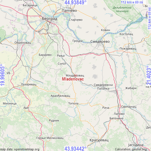
44° 26' 18.996" North, 20° 41' 57.012" East
| Map corner | latitude | longitude |
|---|---|---|
| Upper-left | 44.93849°, | 19.99605° |
| Center: | 44.43861°, | 20.69917° |
| Lower-right: | 43.93442°, | 21.4023° |
| Map W x H: | 111.6×111.6 km | = 69.3×69.3mi |
| max Lat: | 46.1° ⇑72.6% North |
| Mladenovac: | 44.43861° |
| min Lat: | ⇓27.4% South 42.25846° |
| min Long | Mladenovac | max Long |
| 18.9276° | 20.69917° | 22.77556° |
| W 67.1%⇐ | ⇒32.9% E |
Elevation
Elevation of Mladenovac is 169 m = 554 ft, and this is 7.4 m = 24 ft below average elevation for this country.
| Max E: |
1421 m = 4662 ft | 28.3% |
| Avg. | 176.4 m = 579 ft | |
| Mladenovac | 169 m = 554 ft | |
Min E: |
49 m = 161 ft | 71.7% |
See also: Serbia elevation on elevation.city.
Geographical zone
Mladenovac is located in North temperate zone (between Tropic of Cancer and the Arctic Circle). Distance of this Northern Tropic circle is 2335.2 km =1451 mi to South.| Distance of | km | miles | from Mladenovac |
|---|---|---|---|
| North Pole | 5066 | 3147.9 | to North |
| Arctic Circle | 2460.1 | 1528.6 | to North |
| Tropic Cancer | 2335.2 | 1451 | to South |
| Equator | 4941.1 | 3070.3 | to South |


Nearby cities:
15 places around Mladenovac: (largest is in red/bold)
• Aranđelovac
18.3 km =11.4 mi,  217°
217°
• Barajevo
27.4 km =17 mi,  304°
304°
• Grocka
25.9 km =16.1 mi,  3°
3°
• Lazarevac
35.7 km =22.2 mi,  260°
260°
• Lugavčina
30.9 km =19.2 mi,  72°
72°
• Rača
32.3 km =20.1 mi,  136°
136°
• Rušanj
33.7 km =20.9 mi,  324°
324°
• Smederevo
30.9 km =19.2 mi,  35°
35°
• Smederevska Palanka
22.2 km =13.8 mi,  111°
111°
• Sopot
13.4 km =8.3 mi,  312°
312°
• Sremčica
35.9 km =22.3 mi, 317°
• Stepojevac
33.1 km =20.6 mi,  284°
284°
• Topola
20.6 km =12.8 mi,  183°
183°
• Velika Plana
32.2 km =20 mi, 111°
• Vranić
34.6 km =21.5 mi, 301°
Sources, notices
• [Note1] Compared only with cities in Serbia existing in our database
• [Src1] Map data: © OpenStreetMap contributors (CC-BY-SA)
• [Src2] Other city data from geonames.org with taken over terms of usage.
• [Src3] Geographical zone / Annual Mean Temperature by Robert A. Rohde @ Wikipedia
