Mokra Gora geodata
Mokra Gora (Central Serbia) is a populated locality; located in Serbia in Europe/Belgrade (GMT+2) time zone. With population of 605 people, there are 348 cities with bigger population in this country. Compared to other cities in Serbia, 83% of cities are located further ↑North; 88.2% of cities are located further →East and 96.1% of cities have lower elevation than Mokra Gora. Note1


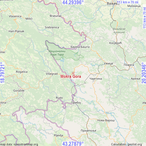
Mokra Gora GPS coordinates[2]
43° 47' 18.708" North, 19° 30' 1.188" East
| Map corner | latitude | longitude |
|---|---|---|
| Upper-left | 44.29396°, | 18.79721° |
| Center: | 43.78853°, | 19.50033° |
| Lower-right: | 43.27879°, | 20.20346° |
| Map W x H: | 112.9×112.9 km | = 70.2×70.2mi |
| max Lat: | 46.1° ⇑83% North |
| Mokra Gora: | 43.78853° |
| min Lat: | ⇓17% South 42.25846° |
| min Long | Mokra Gora | max Long |
| 18.9276° | 19.50033° | 22.77556° |
| W 11.8%⇐ | ⇒88.2% E |
Elevation
Elevation of Mokra Gora is 544 m = 1785 ft, and this is 367.6 m = 1206 ft above average elevation for this country.
| Max E: |
1421 m = 4662 ft | 3.9% |
| Mokra Gora | 544 m 1785 ft | |
| Avg. | 176.4 m = 579 ft | |
Min E: |
49 m = 161 ft | 96.1% |
See also: Serbia elevation on elevation.city.
Geographical zone
Mokra Gora is located in North temperate zone (between Tropic of Cancer and the Arctic Circle). Distance of this Northern Tropic circle is 2262.9 km =1406.1 mi to South.| Distance of | km | miles | from Mokra Gora |
|---|---|---|---|
| North Pole | 5138.2 | 3192.7 | to North |
| Arctic Circle | 2532.3 | 1573.5 | to North |
| Tropic Cancer | 2262.9 | 1406.1 | to South |
| Equator | 4868.8 | 3025.3 | to South |


Nearby cities:
15 places around Mokra Gora: (largest is in red/bold)
• Arilje
48 km =29.8 mi,  94°
94°
• Bajina Bašta
21 km =13 mi,  14°
14°
• Ivanjica
63.2 km =39.3 mi,  111°
111°
• Kosjerić
39.9 km =24.8 mi,  54°
54°
• Ljubovija
45.7 km =28.4 mi,  347°
347°
• Lučani
51.8 km =32.2 mi,  81°
81°
• Nova Varoš
44.2 km =27.5 mi,  145°
145°
• Požega
43.5 km =27 mi, 81°
• Priboj
22.9 km =14.2 mi,  174°
174°
• Prijepolje
45.9 km =28.5 mi,  164°
164°
• Užice
29 km =18 mi,  74°
74°
• Valjevo
62.8 km =39 mi,  30°
30°
• Zlatibor
17.4 km =10.8 mi, 112°
• Ðurići
8.2 km =5.1 mi,  300°
300°
• Čajetina
17.6 km =10.9 mi,  104°
104°
Sources, notices
• [Note1] Compared only with cities in Serbia existing in our database
• [Src1] Map data: © OpenStreetMap contributors (CC-BY-SA)
• [Src2] Other city data from geonames.org with taken over terms of usage.
• [Src3] Geographical zone / Annual Mean Temperature by Robert A. Rohde @ Wikipedia
